C#中GDAL读写shp图层
目录
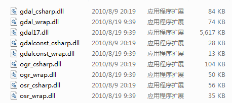
采用GDAL17的C#库进行shp图层属性表读取和修改操作,C#DLL库解压后包含文件如下:

添加引用主要是带csharp的gdal、ogr、osr三个DLL,程序代码如下
using OSGeo.OGR;
using OSGeo.OSR;
using OSGeo.GDAL;
读取shp图层操作
     public void Reforming(string shpFilePath)
{

Gdal.SetConfigOption("GDAL_FILENAME_IS_UTF8", "NO");
            Gdal.SetConfigOption("SHAPE_ENCODING", "");
            Ogr.RegisterAll();// 注册所有的驱动
            DataSource ds = Ogr.Open(shpFilePath, 1);//0表示只读,1表示可修改
            if (ds == null) { MessageBox.Show("打开文件【{0}】失败!", shpFilePath); return; }
            // 获取第一个图层
            int iLayerCount = ds.GetLayerCount();
            Layer oLayer = ds.GetLayerByIndex(0);
            if (oLayer == null) { MessageBox.Show("获取第{0}个图层失败! n", "0"); return; }
            fieldList = GetFieldList(oLayer);//获取图层属性表字段列表
            int featureCount = oLayer.GetFeatureCount(0);
            //B1.判断字段是否存在
            #region shp属性表
            {
                if (!fieldList.Contains("LL_YAW"))
                {
                    FieldDefn oFieldYaw = new FieldDefn("LL_YAW", FieldType.OFTReal);
                    oFieldYaw.SetWidth(10);
                    oFieldYaw.SetPrecision(8);
                    oLayer.CreateField(oFieldYaw, 1);
                }
                if (!fieldList.Contains("LL_ScaleX"))
                {
                    FieldDefn oFieldYaw = new FieldDefn("LL_ScaleX", FieldType.OFTReal);
                    oFieldYaw.SetWidth(10);
                    oFieldYaw.SetPrecision(8);
                    oLayer.CreateField(oFieldYaw, 1);
                }
                if (!fieldList.Contains("LL_ScaleY"))
                {
                    FieldDefn oFieldYaw = new FieldDefn("LL_ScaleY", FieldType.OFTReal);
                    oFieldYaw.SetWidth(10);
                    oFieldYaw.SetPrecision(8);
                    oLayer.CreateField(oFieldYaw, 1);
                }
            }
            #endregion
              //输出属性表字段的详细信息,数据类型、宽度、精度等
              FeatureDefn oDefn1 = oLayer.GetLayerDefn();
            int FieldCount1 = oDefn1.GetFieldCount();
            string headerInfo = string.Empty;
            {
                for (int i = 0; i < FieldCount1; i++)
                {
                    FieldDefn oField = oDefn.GetFieldDefn(i);
                    headerInfo += String.Format("{0}:{1} {2} {3}", oField.GetNameRef(), oField.GetFieldTypeName(oField.GetFieldType()), oField.GetWidth(), oField.GetPrecision());
                    headerInfo += Environment.NewLine;
                }
            }
            MessageBox.Show(headerInfo);


            Feature oFeature = null;
            while ((oFeature = oLayer.GetNextFeature()) != null)
            {
                string name = oFeature.GetFieldAsString(0);
                double x = oFeature.GetFieldAsDouble(1);
                double y = oFeature.GetFieldAsDouble(2);
                double z = oFeature.GetFieldAsDouble(3);

                //B3.给新增加的字段赋值
                oFeature.SetField(7, x);
                oFeature.SetField(8, y);
                oFeature.SetField(9, z);
                oLayer.SetFeature(oFeature);//保存记录
            }
            oLayer.Dispose();
            ds.Dispose();//关闭数据集
        }

private List<string> GetFieldList(Layer mLayer)
        {
            List<string> newFieldList = new List<string>();
            FeatureDefn oDefn = mLayer.GetLayerDefn();
            int FieldCount = oDefn.GetFieldCount();
            for (int i = 0; i < FieldCount; i++)
            {
                FieldDefn oField = oDefn.GetFieldDefn(i);
                string fieldName = oField.GetNameRef();
                newFieldList.Add(fieldName);
            }
            return newFieldList;
        }
}
需要创建或获取shp图层的Spatial Reference空间参考坐标系WKT时,代码如下:
OSGeo.OSR.SpatialReference siref = oLayer.GetSpatialRef();

siref.ExportToWkt(out layerCSWKT);

siref.ImportFromWkt(ref layerCSWKT);
2.创建shp图层,并将点的坐标值写入属性表代码如下:
private void button2_Click(object sender, EventArgs e)
        {
            OSGeo.GDAL.Gdal.SetConfigOption("GDAL_FILENAME_IS_UTF8", "NO");
            // 为了使属性表字段支持中文,请添加下面这句
            OSGeo.GDAL.Gdal.SetConfigOption("SHAPE_ENCODING", "");
            string strVectorFile1 = @"C:\Users\DZY\Desktop\test6";
            Ogr.RegisterAll();

            string strDriver = "ESRI Shapefile";
            Driver oDriver = Ogr.GetDriverByName(strDriver);
            if (oDriver == null)
            {
                MessageBox.Show(" 驱动不可用!\n", strVectorFile1);
                return;
            }
            DataSource ds1 = oDriver.CreateDataSource(strVectorFile1,null);
            if (ds1 == null)
            {
        MessageBox.Show("创建矢量文件【%s】失败!\n", strVectorFile1);
                return;
            }
            string wkt = "…";//自定义投影坐标系的WKT
            OSGeo.OSR.SpatialReference sr = new OSGeo.OSR.SpatialReference(wkt);
            Layer olayer1 = ds1.CreateLayer("PointLayer",sr,wkbGeometryType.wkbPoint,null);
            //接下来创建属性表字段
            // 先创建一个叫FieldID的整型属性
            FieldDefn oFieldID = new FieldDefn("FieldID", FieldType.OFTInteger);
            olayer1.CreateField(oFieldID, 1);

            // 再创建一个叫FeatureName的字符型属性,字符长度为50
            FieldDefn oFieldName = new FieldDefn("FieldName", FieldType.OFTString);
            oFieldName.SetWidth(50);
            olayer1.CreateField(oFieldName, 1);

            //创建x坐标字段
            FieldDefn oFieldX = new FieldDefn("x", FieldType.OFTReal);
            oFieldX.SetWidth(10);
            oFieldX.SetPrecision(8);
            olayer1.CreateField(oFieldX, 1);
            //创建y坐标字段
            FieldDefn oFieldY = new FieldDefn("y", FieldType.OFTReal);
            oFieldY.SetWidth(10);
            oFieldY.SetPrecision(8);
            olayer1.CreateField(oFieldY, 1);
            //创建z坐标字段
            FieldDefn oFieldZ= new FieldDefn("z", FieldType.OFTReal);
            oFieldZ.SetWidth(10);
            oFieldZ.SetPrecision(8);
            olayer1.CreateField(oFieldZ, 1);
            //写入第一条数据
            FeatureDefn oDefn = olayer1.GetLayerDefn();
            Feature oFeature = new Feature(oDefn);
            oFeature.SetField(0, 0);
            oFeature.SetField(1, "Point1");
            oFeature.SetField(2, 489592.624);
            oFeature.SetField(3, 3804367.891);
            oFeature.SetField(4, 386.3);
            Geometry geoPoint = new Geometry(OSGeo.OGR.wkbGeometryType.wkbPoint);
            geoPoint.AddPoint(489592.624, 3804367.891, 386.3);
oFeature.SetGeometry(geoPoint);
            olayer1.CreateFeature(oFeature);

            //写入第二条数据
Feature oFeature1 = new Feature(oDefn);
            oFeature1.SetField(0, 1);
            oFeature1.SetField(1, "Point2");
            oFeature1.SetField(2, 489602.624);
            oFeature1.SetField(3, 3804367.891);
            oFeature1.SetField(4, 389.3);

            geoPoint.AddPoint(489602.624, 3804367.891, 389.3);
            oFeature1.SetGeometry(geoPoint);
            olayer1.CreateFeature(oFeature1);
            oFeature1.Dispose();
            olayer1.Dispose();
            ds1.Dispose();
            MessageBox.Show("shp图层创建完成!");
        }
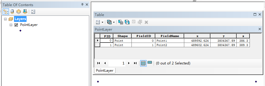
3.ArcMap中加载效果如下:多个点可采取循环遍历的方式实现。