
openlayers加载geoserver发布的WMS与WFS
目录
一、引言
使用openlayer中内置的一些类拓展已经能很好的加载arcgis的图层,比较简单;既然开源就要加载符合开源标准的数据,那必须是要能够加载wms与wfs,但是公共的服务不容易控制,就使用geoserver发布了,发布过程比较简单,请问度娘,这里不多介绍==。openlayers加载geoserver发布的WMS与WFS
二、geoserver中WMS加载
<!DOCTYPE html>
<html lang="en">
<head>
    <meta charset="UTF-8">
    <title>Title</title>
    <script src="js/echarts.min.js"></script>
    <script src="js/jquery-3.3.1.min.js"></script>
    <link rel="stylesheet" href="js/ol.css">
    <script src="js/ol-debug.js"></script>

</head>
<body>
<div id="map" style="width: 100%"></div>
<script>
    var format = 'image/png';
    //view
    var view=new ol.View({
        // 设置成都为地图中心
        center: ol.proj.transform([110,39],"EPSG:4326","EPSG:3857"),
        zoom: 4
    });
    //var osm=new ol.layer.Tile({source: new ol.source.OSM()});

    var wms = new ol.layer.Image({
        source: new ol.source.ImageWMS({
            ratio: 1,
            url: 'http://localhost:8080/geoserver/xcy/wms',
            params: {'FORMAT': format,
                'VERSION': '1.1.1',
                "STYLES": '',
                "LAYERS": 'xcy:bound',
                "exceptions": 'application/vnd.ogc.se_inimage',
            }
        })
    });
    var tiledwms = new ol.layer.Tile({
        //visible: false,
        source: new ol.source.TileWMS({
            url: 'http://localhost:8080/geoserver/xcy/wms',
            params: {'FORMAT': format,
                'VERSION': '1.1.1',
                tiled: true,
                "STYLES": '',
                "LAYERS": 'xcy:bound'
                //"exceptions": 'application/vnd.ogc.se_inimage',
                //tilesOrigin: 8176078.237520734 + "," + 704818.0275364731
            }
        })
    });
    // map
    var map = new ol.Map({
        layers: [
            getTdtLayer("vec_w"),
            getTdtLayer("cva_w"),
            tiledwms
        ],
        view:view,
        target: 'map'
    });

    function getTdtLayer(lyr) {
        var urls=[];
        for(var i=0;i<8;i++)
        {
            urls.push( "http://t"+i+".tianditu.com/DataServer?T=" + lyr + "&X={x}&Y={y}&L={z}")
        }
        var layer = new ol.layer.Tile({
            source: new ol.source.XYZ({
                urls:urls
            })
        });
        return layer;
    }
</script>
</body>
</html>
注意这里的wms加载有两种方式,一种是image,另一种是tile,默认的是使用tile,image没有加载。
两者的区别是tile加载是以切片金字塔的形式加载的,image是每次移动view请求一张图片显示在当前视图。不过两者暂时都没涉及到切片缓存,切片缓存要在geoserver中设置,以后再细讲。
三、geoserver中WFS加载
    var pointTypename="xcy:point";
    var pointVectorSource = new ol.source.Vector({
        format: new ol.format.GeoJSON(),
        url: function(extent) {
            //return 'http://localhost:8080/geoserver/wfs?service=WFS&version=1.1.0&request=GetFeature&typename=xcy:point&outputFormat=application/json&srsname=EPSG:3857&bbox=' + extent.join(',') + ',EPSG:3857';
            //return 'http://localhost:8080/geoserver/xcy/ows?service=WFS&version=1.0.0&request=GetFeature&typeName=xcy:point&maxFeatures=50&outputFormat=application%2Fjson';
            return 'http://localhost:8080/geoserver/xcy/wfs?service=WFS&version=1.0.0&request=GetFeature&typeName='+pointTypename+'&outputFormat=application%2Fjson';
        },
        strategy: ol.loadingstrategy.bbox
    });
    var pointVectorLayer = new ol.layer.Vector({
        source: pointVectorSource,
        style: new ol.style.Style({
            image:new ol.style.Circle({
                radius: 5,
                fill: new ol.style.Fill({
                    color: "#389BCD",
                    opacity: 0.5
                })
            })
        })
    });
这个是wfs的加载方式,wms加载的是图片放到tile图层,因为wfs加载的是矢量数据,所以要放到vector图层里面。
还有一种加载geojson的方式ajax
    $.ajax({
        type: "GET",
        //url: "http://localhost:8080/geoserver/xcy/wfs?service=WFS&request=GetFeature&version=1.1.0&typename=xcy:polygon&outputFormat=json&CQL_FILTER=EntityHand='7E25'",
        //属性查询
        //url: "http://localhost:8080/geoserver/xcy/wfs?service=WFS&request=GetFeature&version=1.1.0&typename=xcy:polygon&outputFormat=json&PROPERTYNAME=Layer&FEATUREID=polygon.2",
        //空间查询
        url: "json/a.geojson" ,

        dataType:'json',
        success: function(data){
            var vectorSource = new ol.source.Vector({
                url:"json/a.geojson",
                format:new ol.format.GeoJSON()
            });
            var vectorLayer = new ol.layer.Vector({
                source: vectorSource,
                style: styleFunction
            });
            map.addLayer(vectorLayer);


        }

    });

/*    var vectorSource = new ol.source.Vector({
        features: (new ol.format.GeoJSON()).readFeatures(geojsonObject)
    });*/
这里已经将vector点图层创建好,可以直接使用将它加载到map中就可以使用,不过要注意的是vector图层有样式设置。
下面是矢量图层的基本框架:
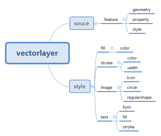
其中矢量点图层可以style有image,矢量线图层有stroke,矢量面图层有stroke和image,text都可以存在;
四、总结
- openlayer加载WMS;
- openlayer加载WFS;
转载自:https://blog.csdn.net/xcymorningsun/article/details/82383321

