

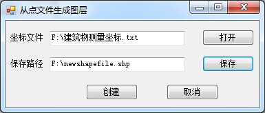
由坐标文件生成shp图层
一、坐标文件


二、实现代码
using System;
using System.Collections.Generic;
using System.ComponentModel;
using System.Data;
using System.Drawing;
using System.Text;
using System.Windows.Forms;
using System.IO;
using ESRI.ArcGIS.Controls;
using ESRI.ArcGIS.Geometry;
using ESRI.ArcGIS.Carto;
using ESRI.ArcGIS.Geodatabase;
using ESRI.ArcGIS.DataSourcesFile;
using ESRI.ArcGIS.esriSystem;
namespace CreateShapefileFromText
{
public partial class Form1 : Form
{
public Form1()
{
InitializeComponent();
}
private AxMapControl buddyMap;
/// <summary>
/// 关联地图控件
/// </summary>
public AxMapControl BuddyMap
{
get { return buddyMap; }
set { buddyMap = value; }
}
string shapeFileFullName = string.Empty;
string surveyDataFullName = string.Empty;
List<string> pColumns = new List<string>();
List<CPoint> pCPointList = new List<CPoint>();
struct CPoint
{
public double x;
public double y;
public string name;
}
private void btnOpen_Click(object sender, EventArgs e)
{
OpenFileDialog pOFD = new OpenFileDialog();
pOFD.Multiselect = false;
pOFD.Title = "打开测量数据坐标文件:";
pOFD.InitialDirectory = System.IO.Directory.GetCurrentDirectory();
pOFD.Filter = "测量坐标文件(*.TXT)|*.TXT";
if (pOFD.ShowDialog() == DialogResult.OK)
{
surveyDataFullName = pOFD.FileName;
this.textBox1.Text = surveyDataFullName;
}
}
private void btnSave_Click(object sender, EventArgs e)
{
SaveFileDialog saveFileDialog = new SaveFileDialog();
saveFileDialog.Filter = "Shape文件(*.shp)|*.shp";
DialogResult dialogresult = saveFileDialog.ShowDialog();
if (dialogresult == DialogResult.OK)
{
shapeFileFullName = saveFileDialog.FileName;
}
else
{
shapeFileFullName = null;
return;
}
this.textBox2.Text = shapeFileFullName;
}
/// <summary>
/// 从测量数据中获取所有点
/// </summary>
/// <param name="surveyDataFullName">测量数据路径</param>
/// <returns>获取的点</returns>
private List<CPoint> GetAllPoint(string surveyDataFullName)
{
List<CPoint> pList = new List<CPoint>();
try
{
if (surveyDataFullName == null || surveyDataFullName == string.Empty)
{
MessageBox.Show("选择野外测量数据!");
return null;
}
if (!System.IO.File.Exists(surveyDataFullName))
{
MessageBox.Show("野外测量数据不存在!");
}
string strLine;
char[] charArray = new char[] { ',' };
string[] strArray;
System.IO.FileStream aFile = new System.IO.FileStream(surveyDataFullName,
FileMode.Open);
StreamReader sr = new StreamReader(aFile, Encoding.Default);
strLine = sr.ReadLine();
strArray = strLine.Split(charArray);
if (strArray.Length > 0)
{
for (int x = 0; x < strArray.Length; x++)
{
pColumns.Add(strArray[x]);
}
}
else
{
return null;
}
strLine = sr.ReadLine();
while (strLine != null)
{
strArray = strLine.Split(charArray);
CPoint pCpoint = new CPoint();
pCpoint.x = Convert.ToDouble(strArray[0]);
pCpoint.y = Convert.ToDouble(strArray[1]);
pCpoint.name = strArray[2].Trim();
pList.Add(pCpoint);
strLine = sr.ReadLine();
}
sr.Close();
}
catch (Exception ex)
{
MessageBox.Show(ex.Message);
}
return pList;
}
/// <summary>
/// 通过点创建shp文件
/// </summary>
/// <param name="outfileNamePath">输出文件路径</param>
/// <returns>创建的shp图层</returns>
private IFeatureLayer CreateShpFromPoints(string outfileNamePath)
{
int index = outfileNamePath.LastIndexOf('\\');
string folder = outfileNamePath.Substring(0, index);
shapeFileFullName = outfileNamePath.Substring(index + 1);
IWorkspaceFactory pWSF = new ShapefileWorkspaceFactoryClass();
IFeatureWorkspace pFWS = (IFeatureWorkspace)pWSF.OpenFromFile(folder, 0);
if(File.Exists(outfileNamePath))
{
IFeatureClass featureClass = pFWS.OpenFeatureClass(shapeFileFullName);
IDataset pDataset = (IDataset)featureClass;
pDataset.Delete();
}
IFields pFields = new FieldsClass();
IFieldsEdit pFieldsEdit;
pFieldsEdit = (IFieldsEdit)pFields;
IField pField = new FieldClass();
IFieldEdit pFieldEdit = (IFieldEdit)pField;
pFieldEdit.Name_2 = "Shape";
pFieldEdit.Type_2 = esriFieldType.esriFieldTypeGeometry;
IGeometryDef pGeometryDef = new GeometryDefClass();
IGeometryDefEdit pGDefEdit = (IGeometryDefEdit)pGeometryDef;
pGDefEdit.GeometryType_2 = esriGeometryType.esriGeometryPolygon;
pFieldEdit.GeometryDef_2 = pGeometryDef;
pFieldsEdit.AddField(pField);
pField = new FieldClass();
pFieldEdit = (IFieldEdit)pField;
pFieldEdit.Length_2 = 20;
pFieldEdit.Name_2 = pColumns[2];
pFieldEdit.Type_2 = esriFieldType.esriFieldTypeString;
pFieldsEdit.AddField(pField);
IFeatureClass pFeatureClass;
pFeatureClass = pFWS.CreateFeatureClass(shapeFileFullName, pFields, null, null,
esriFeatureType.esriFTSimple, "Shape", "");
List<string> pBuildingList = new List<string>();
for (int i = 0; i < pCPointList.Count; i++)
{
if(pBuildingList.Contains(pCPointList[i].name.Trim()) == false)
{
pBuildingList.Add(pCPointList[i].name.Trim());
}
}
for (int i = 0; i < pBuildingList.Count; i++)
{
IPointCollection pPointColl = new PolygonClass();
object o = Type.Missing;
for (int j = 0; j < pCPointList.Count; j++)
{
if (pCPointList[j].name.Trim() == pBuildingList[i].Trim())
{
IPoint pPoint = new PointClass();
pPoint.X = pCPointList[j].x;
pPoint.Y = pCPointList[j].y;
pPointColl.AddPoint(pPoint, ref o, ref o);
}
}
if (pPointColl.PointCount > 0)
{
IClone pClone = pPointColl.get_Point(0) as IClone;
IPoint pEndPoint = pClone.Clone() as IPoint;
pPointColl.AddPoint(pEndPoint, ref o, ref o);
}
IFeature pFeature = pFeatureClass.CreateFeature();
pFeature.Shape = pPointColl as IPolygon;
pFeature.Store();
pFeature.set_Value(pFeature.Fields.FindField(pColumns[2]),
pBuildingList[i].Trim());
pFeature.Store();
}
IFeatureLayer pFeatureLayer = new FeatureLayerClass();
pFeatureLayer.FeatureClass = pFeatureClass;
return pFeatureLayer;
}
private void btnCreate_Click(object sender, EventArgs e)
{
pCPointList = this.GetAllPoint(surveyDataFullName);
IFeatureLayer pFeatureLayer = CreateShpFromPoints(shapeFileFullName);
pFeatureLayer.Name = "建筑物";
//this.buddyMap.Map.AddLayer(pFeatureLayer);
}
private void btnCancel_Click(object sender, EventArgs e)
{
this.Close();
}
}
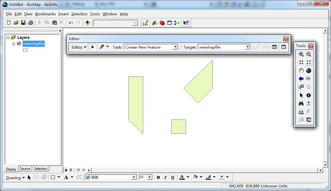
}三、效果图


转载自:https://blog.csdn.net/foreverling/article/details/34423583


