菜鸟末端轨迹(解密支撑每天251亿个包裹的数据库) – 阿里云RDS PostgreSQL最佳实践…
目录
作者:德哥,阿里云数据库专家,PostgreSQL中国社区校长。
标签
PostgreSQL , PostGIS , 多边形 , 面 , 点 , 面点判断 , 菜鸟
————————————————————————————
背景
————————————————————————————
菜鸟末端轨迹项目中涉及的一个关键需求,面面判断。
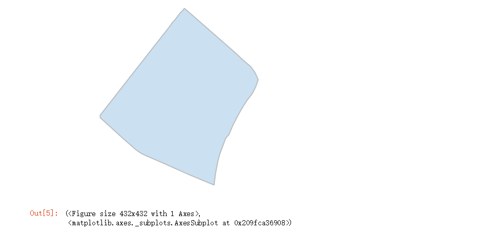
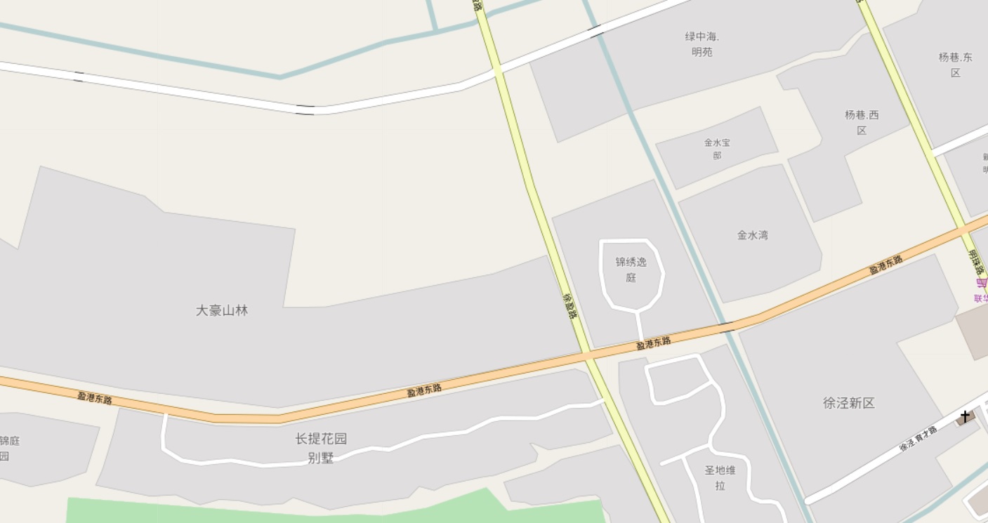
在数据库中存储了一些多边形记录,约几百万到千万条记录,例如一个小区,在地图上是一个多边形。
不同的快递公司,会有各自不同的多边形划分方法(每个网点负责的片区(多边形),每个快递员负责的片区(多边形))。
用户在寄件时,根据用户的位置,查找对应快递公司负责这个片区的网点、或者负责该片区的快递员。
一、需求
————————————————————————————
1. 在数据库中存储了一些静态的面信息,代表小区、园区、写字楼等等。所有的面不相交。
2. 为了支持不同的业务类型,对一个地图,可能划分为不同的多边形组成。
例如不同的快递公司,会有各自不同的多边形划分方法(网点负责的片区(多边形),某个快递员负责的片区(多边形))。
因此在一张地图上,有多个图层,每个图层的多边形划分方法可能不一样。
3. 快速的根据快递公司、客户的位置,求包含这个点的多边形(即得到对应快递公司负责这个片区的网点、或者负责该片区的快递员)。
二、架构设计
————————————————————————————
用到阿里云的RDS PostgreSQL,以及PG提供的PostGIS插件。
我们需要用到PostGIS的函数有两个
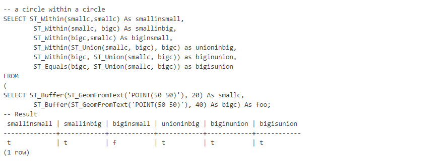
1. ST_within
ST_Within — Returns true if the geometry A is completely inside geometry B
boolean ST_Within(geometry A, geometry B);
Returns TRUE if geometry A is completely inside geometry B. For this function to make sense, the source geometries must both be of the same coordinate projection, having the same SRID. It is a given that if ST_Within(A,B) is true and ST_Within(B,A) is true, then the two geometries are considered spatially equal.
This function call will automatically include a bounding box comparison that will make use of any indexes that are available on the geometries. To avoid index use, use the function _ST_Within.
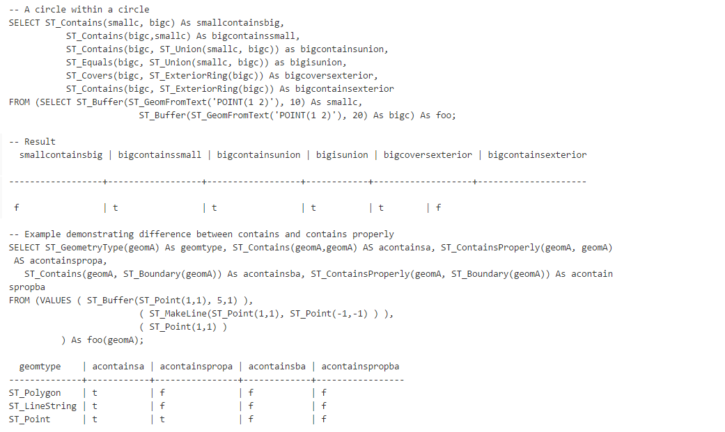
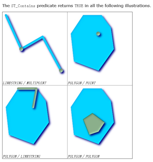
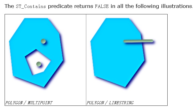
2、ST_Contains
ST_Contains — Returns true if and only if no points of B lie in the exterior of A, and at least one point of the interior of B lies in the interior of A.
boolean ST_Contains(geometry geomA, geometry geomB);
Returns TRUE if geometry B is completely inside geometry A. For this function to make sense, the source geometries must both be of the same coordinate projection, having the same SRID. ST_Contains is the inverse of ST_Within. So ST_Contains(A,B) implies ST_Within(B,A) except in the case of invalid geometries where the result is always false regardless or not defined.
This function call will automatically include a bounding box comparison that will make use of any indexes that are available on the geometries. To avoid index use, use the function _ST_Contains.
三、DEMO与性能
————————————————————————————
1 PG内置几何类型 面点搜索 压测
为了简化测试,采样PG内置的几何类型进行测试,用法与PostGIS是类似的。
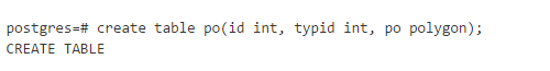
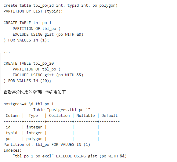
1. 创建测试表
2. 创建分区表或分区索引
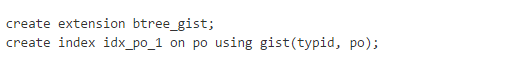
3. 创建空间排他约束,可选
如果要求单个typid内的po不重叠,可以创建空间排他约束
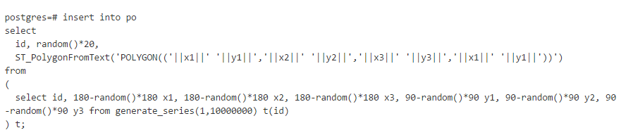
4. 写入1000万多边形测试数据

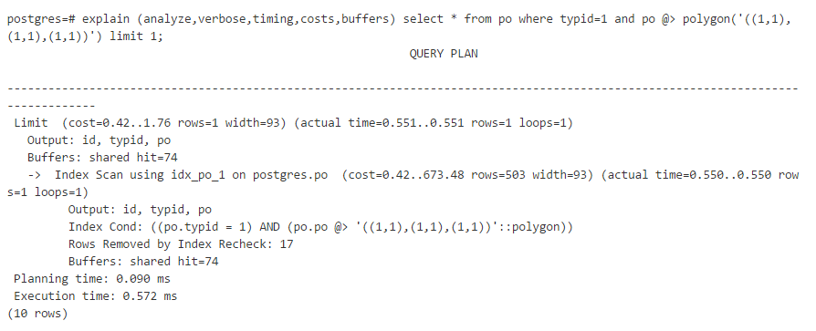
5. 测试面点判断性能
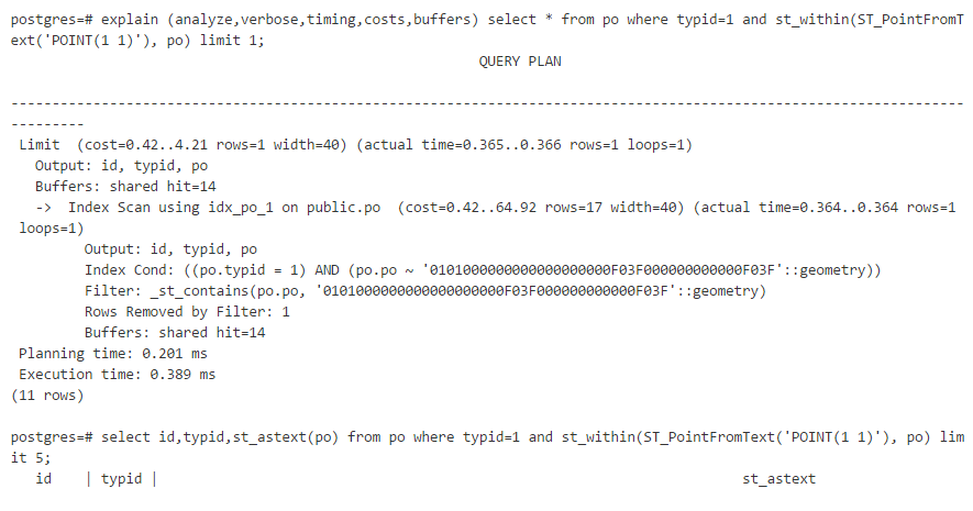
查询包含point(1,1)的多边形,响应时间0.57毫秒。
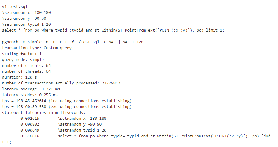
6. 压测
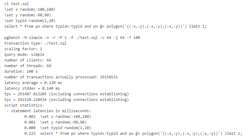
惊不惊喜、意不意外
TPS:29万 ,平均响应时间:0.2毫秒
2 PostGIS空间数据库 面点搜索 压测
阿里云 RDS PostgreSQL,HybridDB for PostgreSQL 已经内置了PostGIS空间数据库插件,使用前创建插件即可。

1. 建表

2. 创建空间索引

3. 写入1000万多边形测试数据
4. 测试面点判断性能
5. 压测
惊不惊喜、意不意外
TPS:19.8万 ,平均响应时间:0.32毫秒
四、技术点
————————————————————————————
1. 空间排他约束
这个约束可以用于强制记录中的多边形不相交。例如地图这类严谨数据,绝对不可能出现两个多边形相交的,否则就有领土纷争了。
PostgreSQL就是这么严谨,意不意外。
2. 分区表
本例中不同的快递公司,对应不同的图层,每个快递公司根据网点、快递员负责的片区(多边形)划分为多个多边形。
使用LIST分区,每个分区对应一家快递公司。
3. 空间索引
GiST空间索引,支持KNN、包含、相交、上下左右等空间搜索。
效率极高。
4. 空间分区索引
《分区索引的应用和实践 – 阿里云RDS PostgreSQL最佳实践》
5. 面面、点判断
面面判断或面点判断是本例的主要需求,用户在寄包裹时,根据用户位置在数据库的一千万多边形中找出覆盖这个点的多边形。
五、云端产品
————————————————————————————
阿里云 RDS PostgreSQL
六、类似场景、案例
————————————————————————————
《PostgreSQL 物流轨迹系统数据库需求分析与设计 – 包裹侠实时跟踪与召回》
七、小结
————————————————————————————
菜鸟末端轨迹项目中涉及的一个关键需求,面面判断。
在数据库中存储了一些多边形记录,约几百万到千万条记录,例如一个小区,在地图上是一个多边形。
不同的快递公司,会有各自不同的多边形划分方法(网点负责的片区(多边形),某个快递员负责的片区(多边形))。
用户在寄件时,根据用户的位置,查找对应快递公司负责这个片区的网点、或者负责该片区的快递员。
使用阿里云RDS PostgreSQL,用户存放约1千万的多边形数据,单库实现了每秒29万的处理请求,单次请求平均响应时间约0.2毫秒。
惊不惊喜、意不意外。
转载自:https://blog.csdn.net/weixin_34040079/article/details/86818262