
So you want a GIS developer job?
If you’re going to be working as a GIS software developer, you’re pretty much going to be a software developer with a concentration in GIS.
Programmers need to be focused because you’re going to be writing, examining, and error-checking code. GIS developers need to learn fast on their feet. GIS programming skills like learning Python, .NET, and C++ are essential.
Alternatively, you could be building web applications using JavaScript, HTML, and CSS. There is also potential to design geospatial applications for field collection, reporting, and other GIS-related activities.
READ MORE: Free GIS Programming Tutorials: Learn How To Code
GIS developer career trends and salary
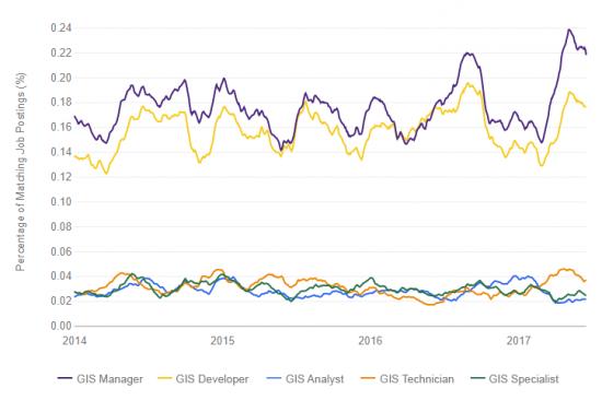
According to Indeed job trends, GIS programmers and developers are one of the highest fields in demand at the moment.
GIS programming and application development have been expanding for quite some time. But most GIS application developer positions are usually accompanied by a computer science degree or certificate.
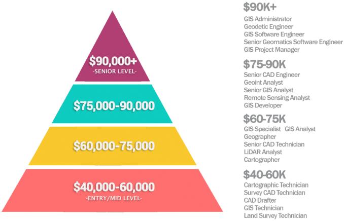
Although GIS developers enjoy higher salaries than average GIS positions, they also require a higher level of education or a combination of work experience. Here are the salary expectations you can expect from this type of career.
GIS developer job advantages/disadvantages
In general, GIS developers have more job stability because software development and computer programming are growing fields.
It’s easier for GIS programmers to land a job because it takes a highly skilled individual to write code and develop applications. No two developers will write the same code. Building an application used by people is often a great feeling for programmers.
Generally, GIS programmers have higher pay rates. But it can really take years to become an expert in the field. Also, it requires a high level of education.
From the level of importance, here are some of the programming languages you can expect: JavaScript, Python, C#, and .NET. But Visual Basic, Flex, Silverlight, Flash, and Arc Macro Language (AML) are on the downtrend or obsolete.
The primary job duties of a GIS developer

PROGRAMMING is the process of writing code and automating redundant GIS processes. Typical programming languages in GIS are Python, SQL, C++, Visual Basic, and Java. It involves GIS programming, web development & design, software application development, and software application lifecycle.
WEB DEVELOPMENT is the process of interactively displaying, processing, or analyzing spatial content on the world-wide-web.
SPATIAL ANALYSIS uses techniques to manipulate, extract, locate and analyze geographic data. Spatial analysis examples include buffering, clipping, and exploring the relationships between map features. It involves GIS analysis, GIS modeling, data integration & conversion, data analysis, geocoding, and Geomatics.
READ MORE: The Periodic Table for Spatial Analysis
Complimentary job duties
CARTOGRAPHY is the study of creating maps. The origin comes from charta – “tablet or leaf of paper” and graph – “to draw”. Areas of study involve information management, softcopy mapping, web mapping, GIS mapping, ArcGIS map design, and quality control/assurance.
REMOTE SENSING involves satellite or aerial imagery to map the Earth. Remote sensing is the study of attaining data without physically being there. Focus areas include remote sensing analysis, satellite/air photo interpretation, global positioning systems (GPS), and soil classification.
DATABASE MANAGEMENT stores information from structured sets of geographic data into relational database management systems. (Database Development, Asset Management Consulting, Database Administration, Data Management Management)
READ MORE: SQL Certification – Structured Query Language
Example GIS Developer Tasks

- Develop, test, debug and maintain an array of custom web-based GIS applications, tools, and supporting web services using standard software life cycle processes
- Support the infrastructure by maintaining and developing new capabilities in Microsoft .Net.
- Develop software in an agile development process by working with stakeholders to refine developed products.
- Perform web and mobile application development using JavaScript, HTML5, CSS, AJAX for the Esri ArcGIS platform
- Provide support, troubleshooting, modifications, enhancements, and maintenance for existing GIS applications, scripts, tools, and web services.
- Create and maintain system-related documentation.
GIS Developer and Job Trends
The GIS job market is growing rapidly, and the demand for GIS developers is growing with it. Learn about the trends and demands for GIS programmers and developers over time.
Stay on top of the latest trends in GIS developer salary information. This map contains salary information for GIS programmers from around the world in different currencies.

Accompanying Software
From the level of importance, here are some of the programming languages you can expect: JavaScript, Python, C#, and .NET.
Additionally, other coding languages include Visual Basic, HTML, JavaScript, XML, SQL, and Spyder.
Common GIS software includes Esri ArcGIS Pro, QGIS 3, CARTO, and Mapbox.