一、Openlayers3通过Geoserver往数据库中添加数据(Transaction操作)
目录
一、结果如下

原始地图显示内容
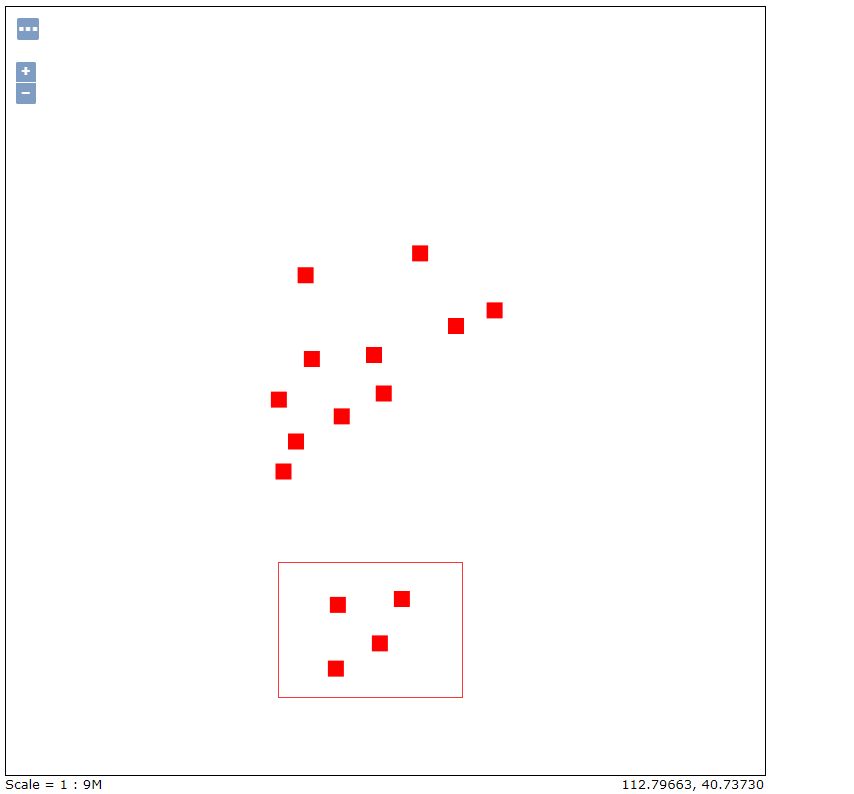
后来增加四个点
二、代码如下
<!DOCTYPE html>
        <html>

    <head>
        <title></title>
        <link href="ol.css" />
        <script src="ol-debug.js"></script>
        <script src="jquery-3.1.1.js"></script>
        <style>
            * {
                margin: 0px;
                padding: 0px;
            }
            html,
            body,
            #map {
                width: 100%;
                height: 100%;
            }
        </style>
    </head>

    <body>
        <div style="position:absolute;top:25px;left:15px;z-index:20"><button id="addPoint">添加点</button></div>
        <div id="map"></div>
        <script>
            var layer = new ol.layer.Tile({
                source: new ol.source.XYZ({
                    url: 'http://www.google.cn/maps/vt?pb=!1m5!1m4!1i{z}!2i{x}!3i{y}!4i256!2m3!1e0!2sm!3i342009817!3m9!2szh-CN!3sCN!5e18!12m1!1e47!12m3!1e37!2m1!1ssmartmaps!4e0&token=32965'
                })
            });
            var vector = new ol.layer.Vector({
                source: new ol.source.Vector()
            });

            var imagewms = new ol.layer.Image({
                source: new ol.source.ImageWMS({
                    url: 'http://localhost:8080/geoserver/HBAJ/wms',
                    params: {
                        format: "image/png",
                        version: '1.1.1',
                        layers: "HBAJ:center_point"
                    }
                })
            });

            var view = new ol.View({
                center: new ol.proj.fromLonLat([120, 30]),
                zoom: 5
            });
            var map = new ol.Map({
                layers: [layer, imagewms, vector],
                view: view,
                target: "map",
                logo: false
            })

            var drawInteraction = new ol.interaction.Draw({
                type: "Point",
                source: vector.getSource()
            });

            var format = new ol.format.WFS();

            var add = document.getElementById("addPoint");
            add.addEventListener("click", function () {
                map.addInteraction(drawInteraction);
            });

            var key = drawInteraction.on("drawend", function (e) {
                var point=new ol.proj.toLonLat(e.feature.getGeometry().getCoordinates());
                var feature = new ol.Feature({
                    geom: new ol.geom.Point([point[1],point[0]])
                });
                var xml = format.writeTransaction([feature], null, null, {
                    featureNS: "www.hbaj.com",//该图层所在工作空间的uri
                    featurePrefix: "HBAJ",//工作空间名称
                    featureType: "center_point",//图层名称
                   // srsName: "EPSG:4326"
                });

                var serializer = new XMLSerializer();
                var featString = serializer.serializeToString(xml);//需要把字符串序列化为xml格式

                $.ajax({
                    url: "http://localhost:8080/geoserver/HBAJ/wfs",
                    type:"POST",
                    data: featString,
                    contentType: 'text/xml',
                    success: function (req) {
                        console.log(req);
                    }
                });
            });
        </script>
    </body>
    </html>
三、问题总结
完成环境:openlayers3.18.2;Geoserver版本为2.8.1
问题一、WFS的1.1.0和2.0.0版本在Geoserver中的经纬度顺序为纬度、经度,而Openlayers默认版本是1.1.0。
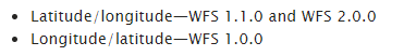
Geoserver官方文档对不同版本的经纬度顺序进行说明
问题二、需要序列化从format中生成的字符串为xml的格式,后台才能够正确解析。
问题三、srsName的作用在是用来直接转换坐标的比如直接把3857坐标转为4326存入数据库。
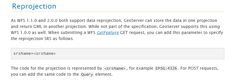
官方文档说明
转载自:https://blog.csdn.net/weixin_33774308/article/details/87125961