
Openlayers 2.X加载天地图
概述:
在前面的章节,讲到了Arcgis for js加载天地图,在本节讲述如何在Openlayers 2.X的版本中加载天地图,并添加自己的wms服务。
效果:
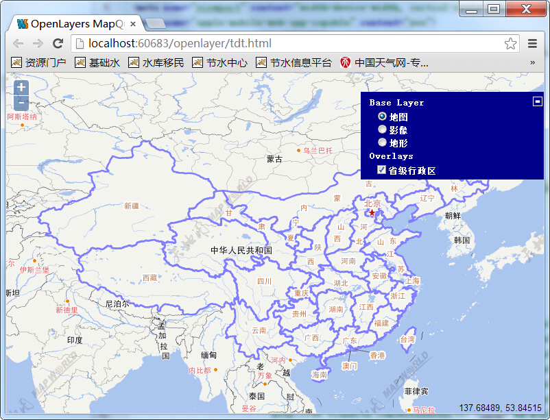
地图
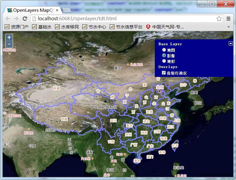
影像

地形
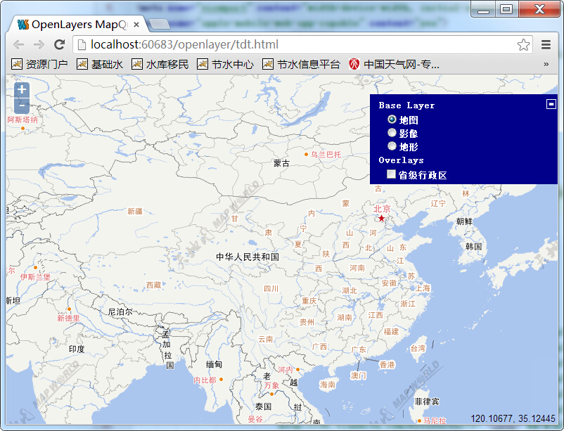
去掉本地wms
实现:
1、天地图服务
在天地图的官方网站上,我们可以看到如下所示的:

页面上列出了我们可调用的图的url,网站地址为:http://www.tianditu.com/guide/index.html。
2、加载天地图
在openlayers中加载天地图可用OpenLayers.Layer.XYZ来实现,在此,我将之封装成了两个函数,getBaseLayer和getAnnoLayer,分别实现基础底图和标注图层,代码如下:
            function getBaseLayer(layername, layer){
                return new OpenLayers.Layer.XYZ(
                        layername,
                        [
                            "http://t0.tianditu.com/DataServer?T="+layer+"&X=${x}&Y=${y}&L=${z}",
                            "http://t0.tianditu.com/DataServer?T="+layer+"&X=${x}&Y=${y}&L=${z}",
                            "http://t0.tianditu.com/DataServer?T="+layer+"&X=${x}&Y=${y}&L=${z}",
                            "http://t0.tianditu.com/DataServer?T="+layer+"&X=${x}&Y=${y}&L=${z}",
                            "http://t0.tianditu.com/DataServer?T="+layer+"&X=${x}&Y=${y}&L=${z}",
                            "http://t0.tianditu.com/DataServer?T="+layer+"&X=${x}&Y=${y}&L=${z}",
                            "http://t0.tianditu.com/DataServer?T="+layer+"&X=${x}&Y=${y}&L=${z}",
                            "http://t0.tianditu.com/DataServer?T="+layer+"&X=${x}&Y=${y}&L=${z}"

                        ],
                        {
                            isBaseLayer: true,
                            displayInLayerSwitcher:true
                        }
                );
            };
            function getAnnoLayer(layername, layer, visiable){
                return new OpenLayers.Layer.XYZ(
                        layername,
                        [
                            "http://t0.tianditu.com/DataServer?T="+layer+"&X=${x}&Y=${y}&L=${z}",
                            "http://t0.tianditu.com/DataServer?T="+layer+"&X=${x}&Y=${y}&L=${z}",
                            "http://t0.tianditu.com/DataServer?T="+layer+"&X=${x}&Y=${y}&L=${z}",
                            "http://t0.tianditu.com/DataServer?T="+layer+"&X=${x}&Y=${y}&L=${z}",
                            "http://t0.tianditu.com/DataServer?T="+layer+"&X=${x}&Y=${y}&L=${z}",
                            "http://t0.tianditu.com/DataServer?T="+layer+"&X=${x}&Y=${y}&L=${z}",
                            "http://t0.tianditu.com/DataServer?T="+layer+"&X=${x}&Y=${y}&L=${z}",
                            "http://t0.tianditu.com/DataServer?T="+layer+"&X=${x}&Y=${y}&L=${z}"

                        ],
                        {
                            isBaseLayer: false,
                            visibility:visiable,
                            displayInLayerSwitcher:false
                        }
                );
            };
调用方式为:
            var baseLayers = ["vec_c","img_c","ter_c"];
            var vecLayer = getBaseLayer("地图",baseLayers[0]);
            var imgLayer = getBaseLayer("影像",baseLayers[1]);
            var terLayer = getBaseLayer("地形",baseLayers[2]);

            var vecAnno = getAnnoLayer("地图标注", "cva_c", true);
完整代码如下:
<!DOCTYPE html>
<html>
<head>
<meta http-equiv="Content-Type" content="text/html; charset=utf-8">
<meta name="viewport" content="width=device-width, initial-scale=1.0, maximum-scale=1.0, user-scalable=0">
<meta name="apple-mobile-web-app-capable" content="yes">
<title>OpenLayers MapQuest Demo</title>
    <link rel="stylesheet" type="text/css" href="http://200.200.200.222/OpenLayers-2.12/theme/default/style.css"/>
    <style type="text/css">
        html, body, #map{
            padding:0;
            margin:0;
            height:100%;
            width:100%;
        }
    </style>
    <script type="text/javascript" src="http://200.200.200.222/OpenLayers-2.12/OpenLayers.js"></script>
    <script type="text/javascript">
        var map;
        function init(){
            function getBaseLayer(layername, layer){
                return new OpenLayers.Layer.XYZ(
                        layername,
                        [
                            "http://t0.tianditu.com/DataServer?T="+layer+"&X=${x}&Y=${y}&L=${z}",
                            "http://t0.tianditu.com/DataServer?T="+layer+"&X=${x}&Y=${y}&L=${z}",
                            "http://t0.tianditu.com/DataServer?T="+layer+"&X=${x}&Y=${y}&L=${z}",
                            "http://t0.tianditu.com/DataServer?T="+layer+"&X=${x}&Y=${y}&L=${z}",
                            "http://t0.tianditu.com/DataServer?T="+layer+"&X=${x}&Y=${y}&L=${z}",
                            "http://t0.tianditu.com/DataServer?T="+layer+"&X=${x}&Y=${y}&L=${z}",
                            "http://t0.tianditu.com/DataServer?T="+layer+"&X=${x}&Y=${y}&L=${z}",
                            "http://t0.tianditu.com/DataServer?T="+layer+"&X=${x}&Y=${y}&L=${z}"

                        ],
                        {
                            isBaseLayer: true,
                            displayInLayerSwitcher:true
                        }
                );
            };
            function getAnnoLayer(layername, layer, visiable){
                return new OpenLayers.Layer.XYZ(
                        layername,
                        [
                            "http://t0.tianditu.com/DataServer?T="+layer+"&X=${x}&Y=${y}&L=${z}",
                            "http://t0.tianditu.com/DataServer?T="+layer+"&X=${x}&Y=${y}&L=${z}",
                            "http://t0.tianditu.com/DataServer?T="+layer+"&X=${x}&Y=${y}&L=${z}",
                            "http://t0.tianditu.com/DataServer?T="+layer+"&X=${x}&Y=${y}&L=${z}",
                            "http://t0.tianditu.com/DataServer?T="+layer+"&X=${x}&Y=${y}&L=${z}",
                            "http://t0.tianditu.com/DataServer?T="+layer+"&X=${x}&Y=${y}&L=${z}",
                            "http://t0.tianditu.com/DataServer?T="+layer+"&X=${x}&Y=${y}&L=${z}",
                            "http://t0.tianditu.com/DataServer?T="+layer+"&X=${x}&Y=${y}&L=${z}"

                        ],
                        {
                            isBaseLayer: false,
                            visibility:visiable,
                            displayInLayerSwitcher:false
                        }
                );
            };

            var baseLayers = ["vec_c","img_c","ter_c"];
            var vecLayer = getBaseLayer("地图",baseLayers[0]);
            var imgLayer = getBaseLayer("影像",baseLayers[1]);
            var terLayer = getBaseLayer("地形",baseLayers[2]);

            var vecAnno = getAnnoLayer("地图标注", "cva_c", true);


            map = new OpenLayers.Map({
                div: "map",
                projection: "EPSG:4326",
                layers: [vecLayer,imgLayer,terLayer],
                numZoomLevels:20,
                center: [103.847, 36.0473],
                zoom: 4
            });
            map.addControl(new OpenLayers.Control.LayerSwitcher());
            map.addControl(new OpenLayers.Control.MousePosition());

            var wms = new OpenLayers.Layer.WMS(
                    "省级行政区",
                    "http://200.200.200.220:8080/geoserver/wms",
                    {
                        LAYERS: "pro",
                        transparent:true
                    },
                    {
                        singleTile: false,
                        ratio: 1,
                        isBaseLayer: false,
                        visibility:true,
                        yx : {'EPSG:4326' : true}
                    }
            );
            map.addLayer(wms);
            map.addLayers([vecAnno]);
        }
    </script>
</head>
<body onload="init()">
    <div id="map"></div>
</body>
转载自:https://blog.csdn.net/GISShiXiSheng/article/details/44621923

