Oracle Spatial空间分析详解
Step1. 创建一张表,其中shape用来存放空间数据
CREATE TABLE mylake (
feature_id NUMBER PRIMARY KEY,
name VARCHAR2(32),
shape MDSYS.SDO_GEOMETRY);
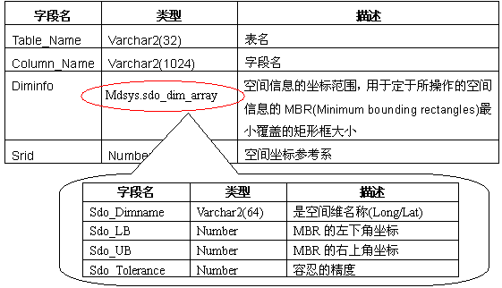
Step2. 在user_sdo_geom_metadata 表中插入新记录,用于描述空间字段
INSERT INTO user_sdo_geom_metadata VALUES (
‘mylake’, //—表名
‘shape’, //—字段名
MDSYS.SDO_DIM_ARRAY(
MDSYS.SDO_DIM_ELEMENT(‘X’, 0, 100, 0.05), //—X维最小,最大值和容忍度。
MDSYS.SDO_DIM_ELEMENT(‘Y’, 0, 100, 0.05) //—Y维最小,最大值和容忍度
),
NULL //—坐标系,缺省为笛卡尔坐标系
);
Step3. 创建空间索引
CREATE INDEX mylake_idx ON mylake(shape)
INDEXTYPE IS MDSYS.SPATIAL_INDEX
Step4. 插入空间数据
Oracle Spatial用MDSYS.SDO_GEOMETRY来存储空间数据,定义为:CREATE TYPE sdo_geometry AS OBJECT (
SDO_GTYPE NUMBER,
SDO_SRID NUMBER,
SDO_POINT SDO_POINT_TYPE,
SDO_ELEM_INFO MDSYS.SDO_ELEM_INFO_ARRAY,
SDO_ORDINATES MDSYS.SDO_ORDINATE_ARRAY);
SDO_GTYPE:用四个数字定义了所有的形状
第一位:维数
第二位:线性表示。用于3,4维数据,二维为0
最后两位:
ValueGeometryDescription

00

UNKNOWN_GEOMETRY

Spatial ignores this value

01

POINT

A single point element

02

LINE or CURVE

Contains one line string element that may be linear, curved or both

03

POLYGON

Contains one polygon element with or without other polygon elements in it

04

COLLECTION

A heterogeneous collection of elements

05

MULTIPOINT

Contains one or more points

06

MULTILINE or MULTICURVE

Contains one or more line string elements

07

MULTIPOLYGON

Contains multiple polygon elements that maybe disjoint
SDO_SRID:坐标系,NULL为笛卡尔坐标系。
SDO_POINT:Oracle Spatial也可定义单个的点,SDO_POINT的定义: CREATE TYPE sdo_point_type AS OBJECT (X NUMBER,Y NUMBER,Z NUMBER);
如果是二维,Z为NULL。
SDO_ELEM_INFO:每三个值描述一个元素。
第一个值:第一个顶点在SDO_ORDINATES_ARR开始位置
第二个值:元素类型
第三个值:顶点连接方式:1-通过直线连接,2-通过圆弧连接
定义为 CREATE TYPE sdo_elem_info_array AS VARRAY (1048576) of NUMBER;SDO_ORDINATES:几何图形所有顶点列表。定义为 CREATE TYPE sdo_ordinate_array AS VARRAY (1048576) of NUMBER;
FONT color=#003366>// 插入包含一个岛屿的湖泊INSERT INTO mylake VALUES(
10,
'Lake Calhoun',
MDSYS.SDO_GEOMETRY(
2003,
NULL,
NULL,
MDSYS.SDO_ELEM_INFO_ARRAY(1,1003,1, 19,2003,1),
MDSYS.SDO_ORDINATE_ARRAY(0,0, 10,0, 10,10, 0,10, 0,0, 4,4, 6,4, 6,6, 4,6, 4,4)
));
// 插入两艘小船INSERT INTO mylake VALUES(
11,
'The Windswept',
MDSYS.SDO_GEOMETRY(
2003,
NULL,
NULL,
MDSYS.SDO_ELEM_INFO_ARRAY(1,1003,1),
MDSYS.SDO_ORDINATE_ARRAY(2,2, 3,2, 3,2, 2,3, 2,2)
)
);
INSERT INTO mylake VALUES(
12,
'Blue Crest',
MDSYS.SDO_GEOMETRY(
2003,
NULL,
NULL,
MDSYS.SDO_ELEM_INFO_ARRAY(1,1003,1),
MDSYS.SDO_ORDINATE_ARRAY(7,7, 8,7, 8,7, 7,8, 7,7)
)
);
Step4. 查询
Oracle Spatial查询数据包括二个处理过程:
1.只通过索引查询候选项。通过函数SDO_FILTER实现:SDO_FILTER(geometry1 MDSYS.SDO_GEOMETRY, geometry2 MDSYS.SDO_GEOMETRY, params VARCHAR2)geometry1: 必须是被索引的几何数据
geometry2:不一定是表中的空间字段,也不要求被索引
params:Filter类型
querytype=WINDOW:geometry2不要求来自表
querytype=JOIN:geometry2必须来自表
SELECT name boat_name
FROM mylake t
WHERE feature_id = 12
AND SDO_FILTER(t.shape, mdsys.sdo_geometry(2003,NULL,NULL,
mdsys.sdo_elem_info_array(1,1003,1),
mdsys.sdo_ordinate_array(2,2, 5,2, 5,5, 2,5, 2,2)),
‘querytype=WINDOW’) = ‘TRUE’;
2.再检查每个候选项是否和条件精确匹配。通过函数SDO_RELATE实现:
SDO_RELATE(geometry1 MDSYS.SDO_GEOMETRY, geometry2 MDSYS.SDO_GEOMETRY, params VARCHAR2)
params:masktype类型
DISJOINT — the boundaries and interiors do not intersect
TOUCH — the boundaries intersect but the interiors do not intersect
OVERLAPBDYDISJOINT — the interior of one object intersects the boundary and interior of the other object, but the two boundaries do not intersect. This relationship occurs, for example, when a line originates outside a polygon and ends inside that polygon.
OVERLAPBDYINTERSECT — the boundaries and interiors of the two objects intersect
EQUAL — the two objects have the same boundary and interior
CONTAINS — the interior and boundary of one object is completely contained in the interior of the other object
COVERS — the interior of one object is completely contained in the interior of the other object and their boundaries intersect
INSIDE — the opposite of CONTAINS. A INSIDE B implies B CONTAINS A.
COVEREDBY — the opposite of COVERS. A COVEREDBY B implies B COVERS A.
ON — the interior and boundary of one object is on the boundary of the other object (and the second object covers the first object). This relationship occurs, for example, when a line is on the boundary of a polygon.
ANYINTERACT — the objects are non-disjoint.
// 选择在定义矩形内的所有小船
SELECT name boat_name
FROM mylake t
WHERE feature_id = 12
AND SDO_FILTER(t.shape, mdsys.sdo_geometry(2003,NULL,NULL,
    mdsys.sdo_elem_info_array(1,1003,1),
    mdsys.sdo_ordinate_array(2,2, 5,2, 5,5, 2,5, 2,2)),
    'querytype=WINDOW') = 'TRUE'
AND SDO_RELATE(t.shape, mdsys.sdo_geometry(2003,NULL,NULL,
    mdsys.sdo_elem_info_array(1,1003,1),
    mdsys.sdo_ordinate_array(2,2, 5,2, 5,5, 2,5, 2,2)),
    'masktype=INSIDE querytype=WINDOW') = 'TRUE'
// masktype可联合使用SELECT feature_id id
FROM mylake t
WHERE feature_id = 12
AND SDO_FILTER(t.shape, mdsys.sdo_geometry(2003,NULL,NULL,
mdsys.sdo_elem_info_array(1,1003,1),
mdsys.sdo_ordinate_array(2,2, 5,2, 5,5, 2,5, 2,2)),
'querytype=WINDOW') = 'TRUE'
AND SDO_RELATE(t.shape, mdsys.sdo_geometry(2003,NULL,NULL,
mdsys.sdo_elem_info_array(1,1003,1),
mdsys.sdo_ordinate_array(2,2, 5,2, 5,5, 2,5, 2,2)),
'masktype=INSIDE+TOUCH querytype=WINDOW') = 'TRUE'
Oracle Spatial 提供的其他查询函数:
Query

Description

SDO_NN

Nearest neighbor

SDO_SDO_WITHIN_DISTANCE

All geometries with a certain distance


Functions

Description

SDO_GEOM.SDO_MBR

The minimum bounding rectangle for a geometry

SDO_GEOM.SDO_DISTANCE

The distance between two geometries

SDO_GEOM.SDO_INTERSECTION

Provides the intersection point of two geometries
转载自:https://blog.csdn.net/ljz9425/article/details/6239251