Types of Remote Sensing
If the sun disappeared, which type of sensor would miss it most? Would it be passive or active sensors?
If you can answer this question, it will help you understand the concept of active and passive sensors in remote sensing.
Active sensors have their own source of light or illumination. In particular, it actively sends a pulse and measures the backscatter reflected to the sensor.
But passive sensors measure reflected sunlight emitted from the sun. When the sun shines, passive sensors measure this energy. More on this later.
Active sensors
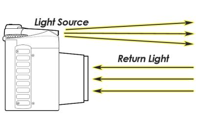
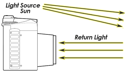
When you take a picture with the flash turned on, the camera sends its own source of light. After it illuminates the target, the camera captures the reflected light back to the camera lens.
So, cameras are active sensors when the photographer uses flash. It illuminates its target and measures the reflected energy back to the camera.
“You can think of active sensors like a handheld camera with the flash turned on.”
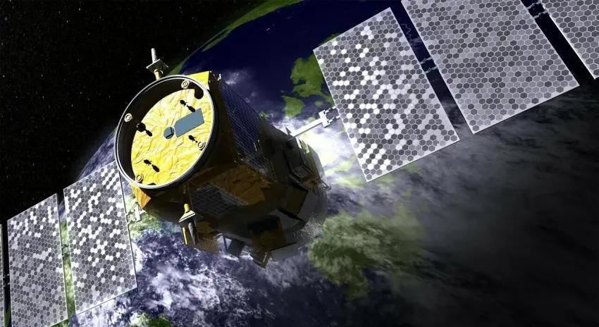
But active remote sensing comes in many forms. For example, they can be satellites orbiting the Earth, helicopters in the air, or anything on the ground too. Just as long as it has an active sensor.
Passive sensors
Cameras are passive sensors when the photographer does not use the flash. Because the camera is not sending the source of light, it uses naturally emitted light from the sun.
Passive sensors use naturally emitted light from the sun. Without the sun, there wouldn’t be passive remote sensing.
As you’re about to find out, there are hundreds of remote sensing applications that use passive and active sensors. But first, let’s dig a bit deeper into both types of remote sensing.
Examples of remote sensing
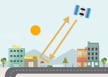
Now that we have a clear understanding of passive and active remote sensing, let’s see it in action for satellite sensors. In the schematic below, you can see how the sun emits light. First, light passes through the atmospheric window. Then, it reflects off Earth to a satellite sensor orbiting Earth.
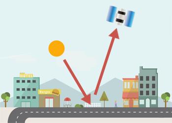
Whereas active sensors illuminate their target. In this example, it’s a side-looking sensor that sends its own pulse to the Earth’s surface. First, it bounces off the ground. Then, it bounces again off a building. Finally, it returns to the sensor again. Actually, this type of backscatter is called double bounce backscatter. More on this later.
Active remote sensing example
If you ever have a chance to see a synthetic aperture radar image, it will look speckled like this:
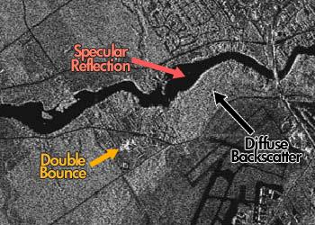
For the untrained eye, it’s just a bunch of black and white pixels. But the reality is that there’s more than meets the eye. For example, the 3 main types of backscatter are:
- Specular reflection
- Double-bounce
- Diffuse scattering
SPECULAR REFLECTION: Specular reflection is where dark spots are in the image. In this case, it’s the smooth surfaces like the east-west flowing river and paved surfaces.
DOUBLE-BOUNCE: The bright white in the center is double-bounce backscatter at work. As shown in the schematic above, it’s an urban feature like a building but it’s not entirely clear at this scale.
DIFFUSE SCATTERING: Finally, the majority of the radar image is rough surface and diffuse scattering. This may be from the growing vegetation in the agricultural areas.
Passive remote sensing example
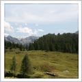
Really, passive remote sensing can be very similar to how our eyes interpret the world. For example, here are the Rocky Mountains in true color.
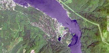
But the power of passive remote sensing is to see light in the whole electromagnetic spectrum. For example, this multispectral image can have different band combinations like color infrared.
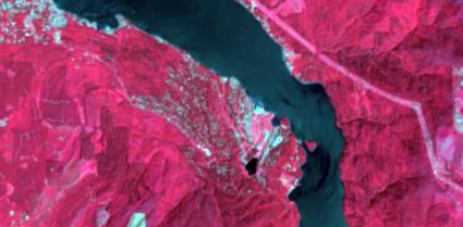
What’s important to realize is that how it emphasizes healthy vegetation in bright red. To say the least, there is a lot of it in this scene. While the bright white is built-up areas, the darkest shade is water. In the east, this could be a transmission line right-of-way because of how it’s constantly the same width.
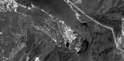
Finally, you can see the world much sharper using the panchromatic band. If you want to pan-sharpen an image, this is the spectral band that you use. Here’s a list of the band combinations for Landsat 8 to see the world in a whole new way.
Uses and applications
Passive remote sensing uses and applications
In terms of passive remote sensing, the Landsat mission is the longest-running earth observation program.
For over 40 years, Landsat has collected and documented our changing planet. Landsat science helps understand Earth’s climate, ecosystems, and land use.
For over 40 years, the Landsat missions have been an eyewitness to our changing planet. Because of it, we have a historical barometer where we gauge change and plan our future as a planet.
Researchers have published thousands of publications using Landsat data. Also, DigitalGlobe and Planet Labs are commercial satellites with hundreds of remote sensing applications & uses
Active remote sensing uses and applications
Two of the key advantages of active remote sensing are:
- The capability to collect imagery night and day.
- It is unfazed by clouds and poor weather conditions.
The Shuttle Radar Topography Mission (SRTM) uses inSAR which measures Earth’s elevation with two antennas. In only a couple of days, SRTM has collected one of the most accurate digital elevation models of Earth.

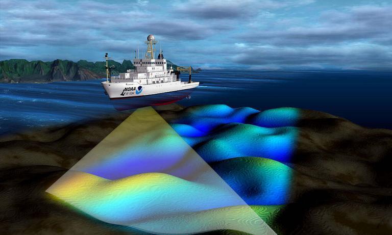
Light detection and Ranging (LiDAR) is an active sensor that measures ground height. Using light from an airplane or helicopter platform measures the time it takes to bounce back to the sensor. From this, you can create Digital Surface Models which are useful in forestry.
Active remote sensing has been used for a variety of security applications including marine and Arctic monitoring. As shown previously, the double-bounce scattering has provided critical information in search and rescue missions.
Active sensor examples include the Canadian Space Agency’s RADARSAT-1 and RADARSAT-2 and Airbus Defense & Space TerraSAR-X Radar Satellite.
Passive vs Active Sensors in Remote Sensing
As you learned today, passive sensors would miss the sun if it disappeared. This is because active sensors generate their own source of illumination.
But because passive sensors use reflected energy from the sun, it needs the sun to work.
If you want to learn more about passive remote sensing, check out our guide on multispectral and hyperspectral sensors. Or if you want to learn more about active remote sensing, take a look at our guide on Light Detection and Ranging.
Alternatively, if you want to work with data, we have a list of 15 free satellite data sources and the top 6 free LiDAR data sources.