geotools编写shp转sql,实现shp数据入Oracle Spatial库
目录
概述
用到Oracle Spatial就很难避免shp文件的入库问题,虽然有shp2sdo工具,但是用起来不是很习惯,所以,本文讲述如何结合geotools实现shp2sql的转换。
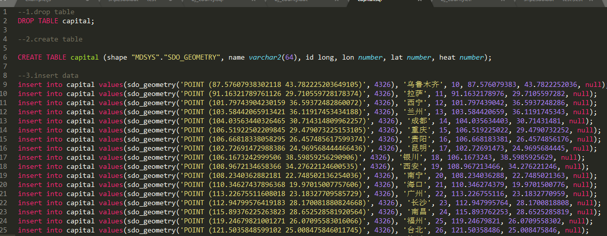
效果
实现代码
package com.lzugis.geotools;

import com.lzugis.CommonMethod;
import com.vividsolutions.jts.geom.Coordinate;
import com.vividsolutions.jts.geom.Geometry;
import com.vividsolutions.jts.geom.GeometryFactory;
import com.vividsolutions.jts.simplify.TopologyPreservingSimplifier;
import org.geotools.data.shapefile.ShapefileDataStore;
import org.geotools.data.simple.SimpleFeatureCollection;
import org.geotools.data.simple.SimpleFeatureIterator;
import org.geotools.data.simple.SimpleFeatureSource;
import org.geotools.factory.CommonFactoryFinder;
import org.geotools.filter.text.cql2.CQL;
import org.opengis.feature.simple.SimpleFeature;
import org.opengis.feature.simple.SimpleFeatureType;
import org.opengis.feature.type.AttributeDescriptor;
import org.opengis.feature.type.AttributeType;
import org.opengis.filter.Filter;
import org.opengis.filter.FilterFactory2;
import scala.util.parsing.combinator.testing.Str;

import java.io.File;
import java.nio.charset.Charset;
import java.util.ArrayList;
import java.util.HashMap;
import java.util.List;
import java.util.Map;
import com.lzugis.geotools.model.Fields;

public class Shp2Orcale {
    private final Map<String, String> fMap = new HashMap<>();

    private SimpleFeatureSource featureSource = null;
    private String tableName = "";
    private List<Fields> fields = new ArrayList<>();
    private CommonMethod cm = new CommonMethod();

    public Shp2Orcale(){
        fMap.put("string", "varchar2(64)");
        fMap.put("long", "long");
        fMap.put("double", "number");
        fMap.put("shape", "\"MDSYS\".\"SDO_GEOMETRY\"");
    }

    public void readShape(String shpfile){
        try {
            File file = new File(shpfile);
            ShapefileDataStore shpDataStore = null;

            shpDataStore = new ShapefileDataStore(file.toURL());
            //设置编码
            Charset charset = Charset.forName("GBK");
            shpDataStore.setCharset(charset);
            tableName = shpDataStore.getTypeNames()[0];
            featureSource =  shpDataStore.getFeatureSource (tableName);
        }catch (Exception e){
            e.printStackTrace();
        }
    }

    public void getShpFields(){
        SimpleFeatureType schema = featureSource.getSchema();
        List<AttributeDescriptor> attrs= schema.getAttributeDescriptors();
        for(int i=0;i<attrs.size();i++){
            AttributeDescriptor attr = attrs.get(i);
            Class<?> cls = attr.getType().getBinding();
            String clsName = cls.getName();
            clsName = clsName.substring(clsName.lastIndexOf(".")+1).toLowerCase();
            Fields field = new Fields(attr.getLocalName(), clsName);
            fields.add(field);
        }
    }

    public void createTableSql(String sqlpath){
        cm.append2File(sqlpath, "--1.drop table\r\nDROP TABLE "+tableName+";");
        cm.append2File(sqlpath, "\r\n--2.create table\r\n");
        StringBuffer sql = new StringBuffer();
        sql.append("CREATE TABLE "+tableName+" (");
        for(int i=0, size = fields.size();i<size;i++){
            Fields field = fields.get(i);
            String filedname = field.getFieldmame().toLowerCase();
            filedname = filedname.equals("the_geom")?"shape":filedname;
            String fieldtype = field.getFieldtype();
            fieldtype = filedname.equals("shape")?"shape":fieldtype;
            sql.append(filedname+" "+fMap.get(fieldtype));
            if(i!=size-1) sql.append(", ");
        }
        sql.append(");");
        cm.append2File(sqlpath, sql.toString());
    }

    public void insertValueSql(String sqlpath) {
        try {
            cm.append2File(sqlpath, "\r\n--3.insert data");

            SimpleFeatureCollection result = featureSource.getFeatures();
            SimpleFeatureIterator itertor = result.features();

            StringBuffer sql = new StringBuffer();
            while (itertor.hasNext()){
                SimpleFeature feature = itertor.next();
                StringBuffer _sql = new StringBuffer();
                _sql.append("insert into "+tableName+" values(");
                for(int i=0, size = fields.size();i<size;i++){
                    Fields field = fields.get(i);
                    String filedname = field.getFieldmame();
                    filedname = filedname=="the_geom"?"shape":filedname;
                    String fieldtype = field.getFieldtype();

                    if(filedname!="shape"){
                        if(fieldtype.equals("string")){
                            _sql.append("'"+feature.getAttribute(filedname)+"'");
                        }else {
                            _sql.append(feature.getAttribute(filedname));
                        }
                    }else{
                        Geometry geom = (Geometry)feature.getAttribute("the_geom");
                        _sql.append("sdo_geometry('"+geom.toString()+"', 4326)");
                    }
                    if(i!=size-1) _sql.append(", ");
                }
                _sql.append(");\r\n");
                sql.append(_sql);
            }
            cm.append2File(sqlpath, sql.toString());
        }catch (Exception e){
            e.printStackTrace();
        }
    }

    /**
     * 工具类测试方法
     * @param args
     */
    public static void main(String[] args) {
        Shp2Orcale shp2orcl =new Shp2Orcale();
        String shppath = "D:\\data\\wgs84\\capital.shp";
        String sqlpath = "D:\\data\\wgs84\\sql\\capital.sql";
        try{
            long start = System.currentTimeMillis();
            //读取shp文件
            shp2orcl.readShape(shppath);
            shp2orcl.getShpFields();
            shp2orcl.createTableSql(sqlpath);
            shp2orcl.insertValueSql(sqlpath);
            System.out.println("共耗时"+(System.currentTimeMillis() - start)+"ms");
        }
        catch(Exception e){
            e.printStackTrace();
        }
    }
}
说明:
1、对于比较复杂的线或面会出现sql太长的问题,文章里面加了一行简化的代码;
技术博客
CSDN:http://blog.csdn.NET/gisshixisheng
在线教程
https://edu.csdn.net/course/detail/799
https://edu.csdn.net/course/detail/7471
联系方式
| 类型 | 内容 |
|---|---|
| 1004740957 | |
| 公众号 | lzugis15 |
| niujp08@qq.com | |
| webgis群 | 452117357 |
| Android群 | 337469080 |
| GIS数据可视化群 | 458292378 |
“GIS讲堂”知识星球开通了,在星球,我将提供一对一的问答服务,你问我答,期待与你相见。

转载自:https://blog.csdn.net/GISShiXiSheng/article/details/80834015