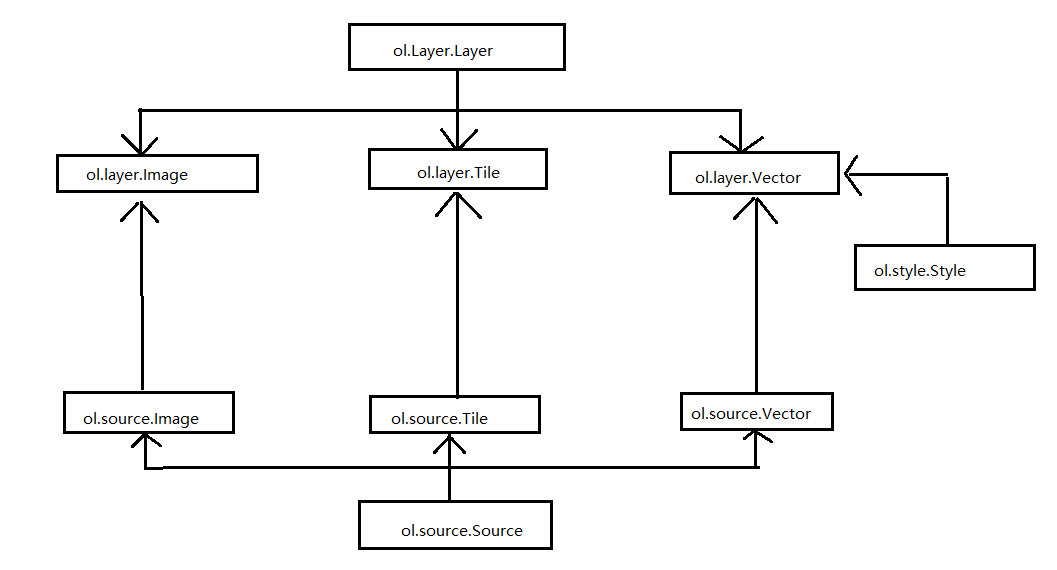
openlayers3加载OSM、BingMaps、百度地图、天地图、wfs图层
<html>
<head>
    <meta http-equiv="Content-Type" content="text/html; charset=utf-8" />
    <title>加载图层控件(自定义)</title>
    <link rel="stylesheet" type="text/css" href="./css/ol.css"/>
    <script type="text/javascript" src="./js/ol.js"></script>
    <style type="text/css">
        body, html, div, ul, li, iframe, p, img {
            border: none;
            padding: 0;
            margin: 0;
            font-size: 14px;
            font-family: "微软雅黑";
        }

        #mapCon {
            width: 100%;
            height: 95%;
            position: absolute;
        }
        /* 图层控件层样式设置 */
        .layerControl {
            position: absolute;
            bottom: 5px;
            min-width: 200px;
            max-height: 240px;
            right: 0px;
            top: 5px;
            /*在地图容器中的层,要设置z-index的值让其显示在地图上层*/
            z-index: 2001;
            color: #ffffff;
            background-color: #4c4e5a;
            /*边缘的宽度*/
            border-width: 10px;
            /*圆角的大小 */
            border-radius: 10px;
            /*边框颜色*/
            border-color: #000 #000 #000 #000;
        }

            .layerControl .title {
                font-weight: bold;
                font-size: 15px;
                margin: 10px;
            }

        .layerTree li {
            list-style: none;
            margin: 10px 10px;
        }
        /* 鼠标位置控件层样式设置 */
        #mouse-position {
            float: left;
            position: absolute;
            bottom: 5px;
            width: 330px;
            height: 20px;
            /*在地图容器中的层,要设置z-index的值让其显示在地图上层*/
            z-index: 2000;
        }
    </style>
</head>
<body>
    <div id="mapCon">
        <div id="mouse-position"></div>
        <div id="layerControl" class="layerControl">
            <div class="title"><label>图层列表</label></div>
            <ul id="layerTree" class="layerTree"></ul>
        </div>
    </div>
    <script type="text/javascript">
	      //加载百度地图
	        var projection = ol.proj.get("EPSG:3857");
            var resolutions = [];
			for (var i = 0; i < 19; i++) {
			resolutions[i] = Math.pow(2, 18 - i);
			}
			var tilegrid = new ol.tilegrid.TileGrid({
			origin: [0, 0],
			resolutions: resolutions
			});

			var baidu_source = new ol.source.TileImage({
				projection: projection,
				tileGrid: tilegrid,
				tileUrlFunction: function (tileCoord, pixelRatio, proj) {
				if (!tileCoord) {
					return "";
				}
				var z = tileCoord[0];
				var x = tileCoord[1];
				var y = tileCoord[2];

				if (x < 0) {
					x = "M" + (-x);
				}
				if (y < 0) {
					y = "M" + (-y);
				}

				 return "http://online3.map.bdimg.com/onlinelabel/?qt=tile&x=" + x + "&y=" + y + "&z=" + z + "&styles=pl&udt=20151021&scaler=1&p=1";
				}
			});


        //map中的图层数组
        var layer = new Array();
        //图层名称数组
        var layerName = new Array();
        //图层可见属性数组
        var layerVisibility = new Array();

        /**
        * 加载图层列表数据
        * @param {ol.Map} map 地图对象
        * @param {string} id 图层列表容器ID
        */
        function loadLayersControl(map, id) {
            //图层目录容器
            var treeContent = document.getElementById(id);
            //获取地图中所有图层
            var layers = map.getLayers();
            for (var i = 0; i < layers.getLength() ; i++) {
                //获取每个图层的名称、是否可见属性
                layer[i] = layers.item(i);
                layerName[i] = layer[i].get('name');
                layerVisibility[i] = layer[i].getVisible();

                //新增li元素,用来承载图层项
                var elementLi = document.createElement('li');
                // 添加子节点
                treeContent.appendChild(elementLi);
                //创建复选框元素
                var elementInput = document.createElement('input');
                elementInput.type = "checkbox";
                elementInput.name = "layers";
                elementLi.appendChild(elementInput);
                //创建label元素
                var elementLable = document.createElement('label');
                elementLable.className = "layer";
                //设置图层名称
                setInnerText(elementLable, layerName[i]);
                elementLi.appendChild(elementLable);

                //设置图层默认显示状态
                if (layerVisibility[i]) {
                    elementInput.checked = true;
                }
                //为checkbox添加变更事件
                addChangeEvent(elementInput, layer[i]);
            }
        }
        /**
        * 为checkbox元素绑定变更事件
        * @param {input} element checkbox元素
        * @param {ol.layer.Layer} layer 图层对象
        */
        function addChangeEvent(element, layer) {
            element.onclick = function () {
                if (element.checked) {
                    //显示图层
                    layer.setVisible(true);
                }
                else {
                    //不显示图层
                    layer.setVisible(false);
                }
            };
        }
        /**
        * 动态设置元素文本内容(兼容)
        */
        function setInnerText(element, text) {
            if (typeof element.textContent == "string") {
                element.textContent = text;
            } else {
                element.innerText = text;
            }
        }
        var key = 'Q57tupj2UBsQNQdju4xL~xBceblfTd6icjljunbuaCw~AhwA-whmGMsfIpVhslZyknWhFYq-GvWJZqBnqV8Zq1uRlI5YM_qr7_hxvdgnU7nH';
        //实例化Map对象加载地图
        var map = new ol.Map({
            //地图容器div的ID
            target: 'mapCon',
            //地图容器中加载的图层
            layers: [
                //加载瓦片图层数据
                new ol.layer.Tile({
                    source: new ol.source.OSM(),
                    name: '世界地图(OSM瓦片)'
                }),
                new ol.layer.Tile({
                    source: new ol.source.BingMaps({ key: key, imagerySet: 'Road' }),
                    name: "Bing Road"
                }),
                new ol.layer.Tile({
                    source: new ol.source.BingMaps({ key: key, imagerySet: 'Aerial' }),
                    name: "Bing Aerial"
                }),
				new ol.layer.Tile({
				source: baidu_source,
				name:'百度地图'
				}),
				new ol.layer.Tile({
					source: new ol.source.XYZ({
					url:"http://t0.tianditu.com/DataServer?T="+"vec_w"+"&X={x}&Y={y}&L={z}"
					}),
					name:'天地图-全球矢量地图服务'
				}),
				new ol.layer.Tile({
					source: new ol.source.XYZ({
					url:"http://t0.tianditu.com/DataServer?T="+"cva_w"+"&X={x}&Y={y}&L={z}"
					}),
					name:'天地图-全球矢量中文注记服务'
				}),
				 new ol.layer.Tile({
				source:new ol.source.TileWMS({
				url: 'http://localhost:8080/geoserver/map/wms?service=WMS&version=1.1.0&request=GetMap&layers=map:capital&styles=&bbox=87.57607938302118,19.97015007757606,126.56705607814561,45.69385655384421&width=768&height=506&srs=EPSG:4326&format=application/openlayers',
                    params:{
                          'LAYERS':'capital',
                          'TILED':false
                      },
			   serverType:'geoserver'

				}),
				name: "WFS服务"
				})

            ],
            //地图视图设置
            view: new ol.View({
                //地图初始中心点
                center: [0, 0],
                //地图初始显示级别
                zoom: 2
            }),
            controls: ol.control.defaults().extend([
                new ol.control.MousePosition(
                    {
                        target: document.getElementById('mouse-position')
                    }
                )
            ])
        });
        //加载图层列表数据
        loadLayersControl(map, "layerTree");
    </script>
</body>
</html>
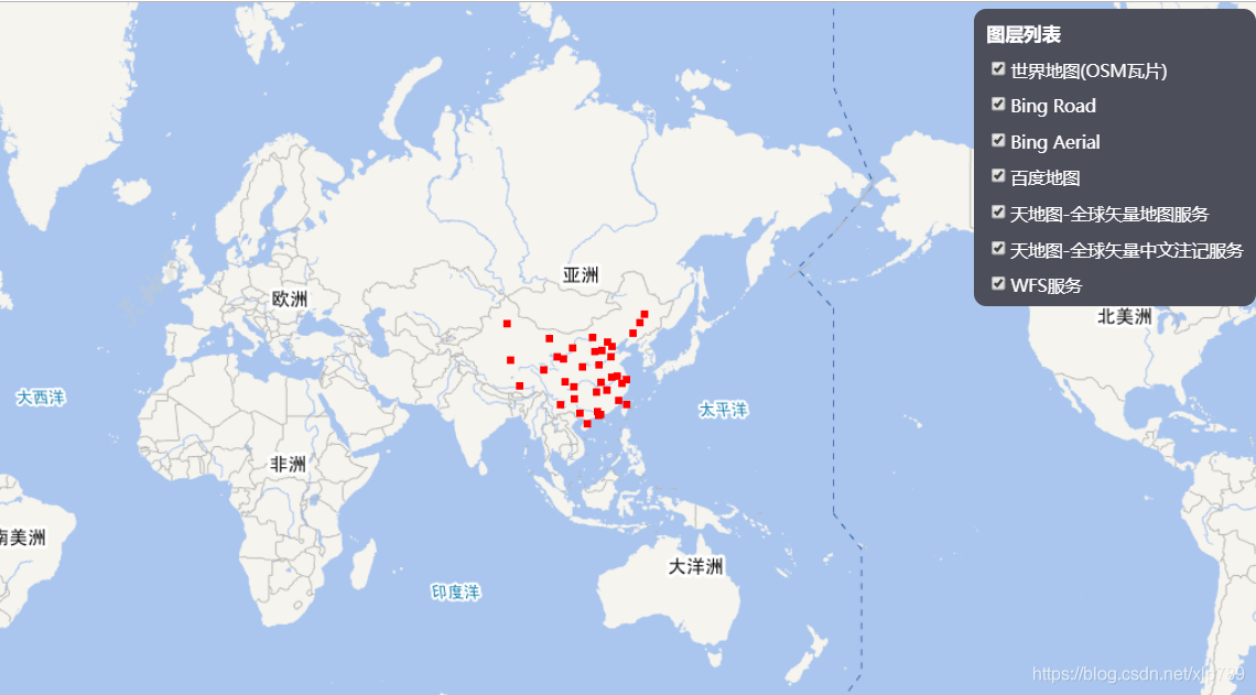
效果图
转载自:https://blog.csdn.net/xlp789/article/details/83550454