Hyperspectral Imaging in Space
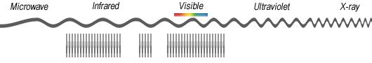
Imagine seeing the world in more spectral detail so you can better understand and discern anything on our planet. Both multispectral and hyperspectral imaging captures reflected light.
Multispectral imaging breaks light into 4 to 36 bands. Then, it assigns those bands names such as red, green, blue, and near infrared.
Hyperspectral imaging does the same. It takes a spectrum of light. But it divides the light into hundreds of narrow spectral bands.
Now that you’ve got the basics, let’s explore hyperspectral imaging from space. What are the past, present, and future of hyperspectral sensors?
A Breakdown of Imaging Types
The major types of imaging are panchromatic, visible with near-infrared (VNIR), multispectral, super-spectral, and hyperspectral.
All types of imaging have loose definitions for their number of spectral bands. The USGS breaks down spectral bands and imaging types as follows:
| Imaging Type | Number of Spectral Bands |
|---|---|
| Panchromatic | 1-2 (Typically) |
| Visible and near infrared | 3-4 (Red, green, blue, and NIR) |
| Multispectral | 5-36 |
| Superspectral | 37+ |
| Hyperspectral | 37+ |
Multispectral Imaging
This multispectral image example shows 5 spectral bands. It has three visible bands assigned as red, green, and blue. There are also 2 bands assigned in the infrared spectrum. Typically, multispectral imaging has bands in the near-infrared (NIR) and short-wave infrared (SWIR). For example, Landsat bands and Sentinel-2 bands have this configuration.
Hyperspectral Imaging
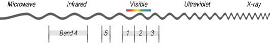
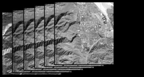
This hyperspectral image example shows narrow bands. We couldn’t draw the bands to scale so this is just a visual depiction to help understand the concept. As you can see, the bands are thin in comparison to the multispectral image.
Typically, there are hundreds of bands in a hyperspectral. After you download a hyperspectral image, you will have hundreds of TIF files for each scene. Each TIF file represents that narrow band of light as described in the sensor’s specifications.
Hyperspectral Satellites in Space
Below, we’ve outlined hyperspectral imaging from the past, present, and future.
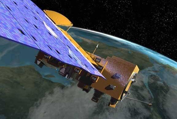
EO-1 (NASA)
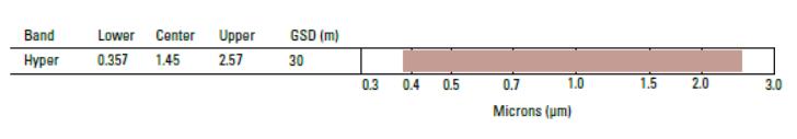
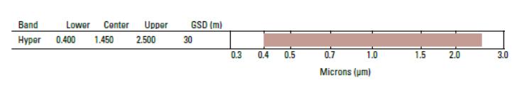
In 2000, NASA launched the EO-1 satellite which carried the hyperspectral sensor “Hyperion”. Hyperion produced 30-meter resolution images in 242 spectral bands. Hyperion really kicked off the start of hyperspectral imaging from space. If you want to test out Hyperion imagery for yourself, the data is available for free on the USGS Earth Explorer.
PROBA-1 (ESA)
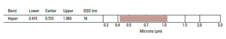
Project for Onboard Autonomy (PROBA-1) was launched by ESA in 2001. It carried CHRIS (Compact High-Resolution Imaging Spectrometer) for medium resolution hyperspectral imaging. Its hyperspectral mode produced 63 bands at 34m GSD. But it could also be reconfigured to 150 bands at a pixel resolution.
PRISMA (Italy)
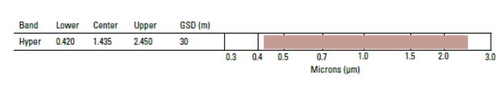
PRISMA was launched in 2019 as a medium-resolution hyperspectral satellite. It’s the first of its kind for Italy and will assist in crop classification, resource management, and environmental monitoring. PRISMA (PRecursore IperSpettrale Della Missione Applicativa) produces 250 bands with 30m GSD.
EnMap (Germany)
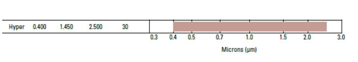
Germany plans to launch Environmental Mapping and Analysis Program (EnMap) in 2020. This hyperspectral satellite will consist of 228 bands with 30m GSD.
HISUI (Japan)
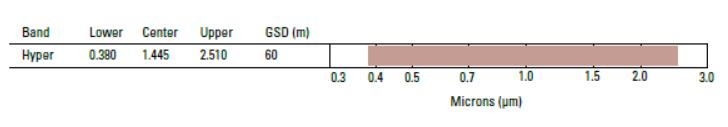
The Hyperspectral and Multispectral Imager (HISUI) will be onboard ALOS-3. This Japanese hyperspectral sensor will have 185 bands with 30m GSD. It’s planning to be launched in 2020.
HyspIRI (United States)
The estimated launch for Hyperspectral Infrared Imager (HyspIRI) is 2024. It will be equipped with the VSWIR imaging spectrometer with 60m GSD.
Is Hyperspectral Imaging the Future of Remote Sensing?
Hyperspectral imaging from space is a bit of a rare commodity. The main reasons are its level of complexity and large data size. For example, a Hyperion image contains 242 individual TIFF files. Each one shows a tiny spectrum of light.
PRO TIP: Go to USGS Earth Explorer to download Hyperion imagery. Check out our tutorial how to download satellite imagery from it.
If you combine all 242 images, the data size is 188 MB (zipped). But the swath is absolutely tiny at 680 km2 (262 mi2). Then if you compare this to a typical Sentinel-2 scene which is 12,000 km2 (4,660 mi2).
But over the years, technology and storage have advanced rapidly. Could hyperspectral imaging be a trend for the future? The answer is yes.
Hyperspectral Imaging Applications
The main idea behind the emergence of hyperspectral imaging is that it gives a greater level of spectral detail. If you have hundreds of narrow bands, you have finer amounts of detail that you can comb through. In turn, you can reveal new information that you didn’t know was possible.
The main areas of usage for hyperspectral imagery can be categorized into 8 groups. This includes vegetation, agriculture, geology, soil, water resources, disaster, and land use.
The underlying principle is that it improves any type of classification. For example, you can get more detail for geologic surface composition. The same is true for vegetation types, soil classes and land cover too.
Hyperspectral imaging helps identify pests for crop management. For water resources, it’s about understanding bathymetry, water quality, and chemistry. And it’s been used for disaster management such as prevention and post-monitoring.
READ MORE: 100 Earth Shattering Remote Sensing Applications & Uses