Leaflet学习笔记-加载北京地铁线路
目录
Leaflet学习笔记-加载北京地铁线路
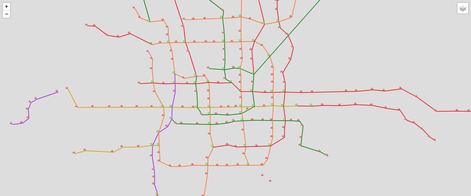
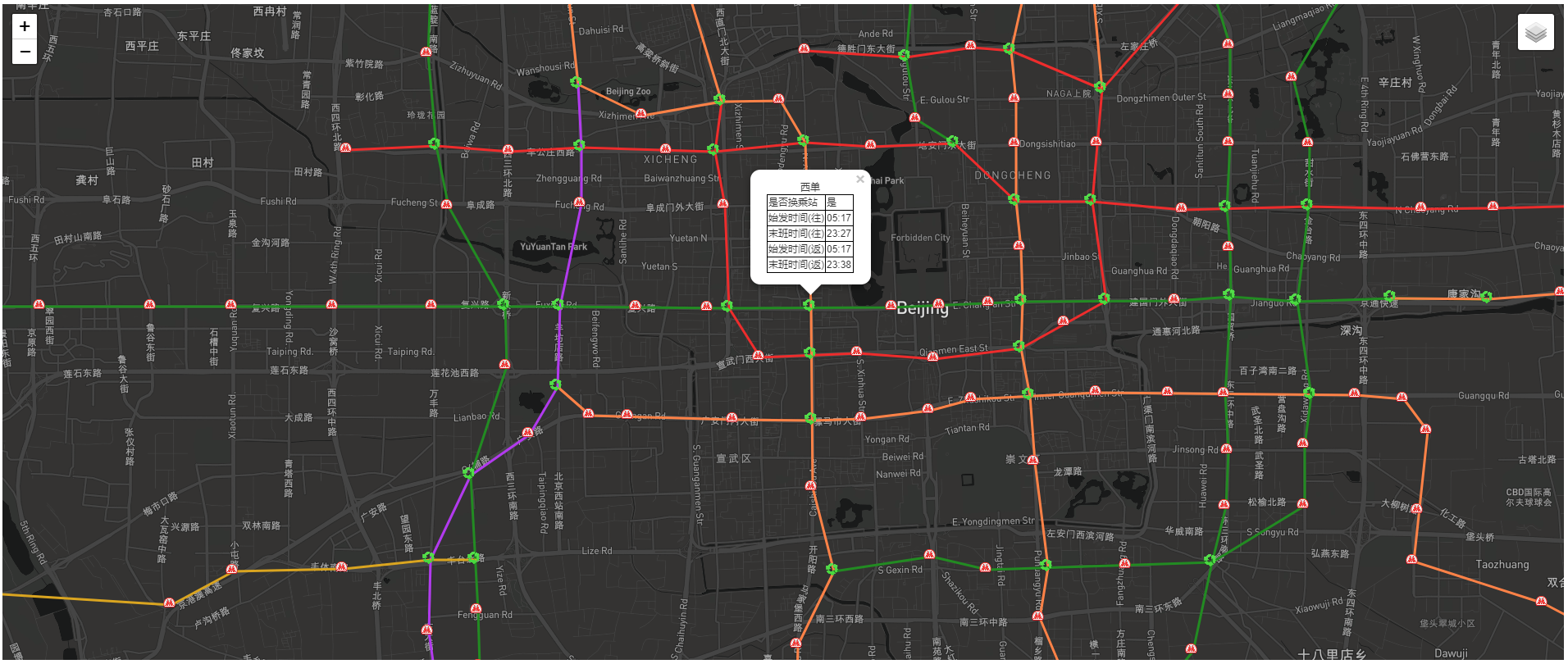
先上效果图
本文主要由两部分组成:
- 获取线路和站点json
- Leaflet加载线路和站点GeoJson
获取线路和站点json
路线json(包含站点坐标)
http://map.amap.com/service/subway?_1524027031909&srhdata=1100_drw_beijing.json
站点json(包含时间等)
http://map.amap.com/service/subway?_1524027031912&srhdata=1100_info_beijing.json
路线数据和站点数据都是以线路组织的。
利用高德地图抓取数据
router.get('/', async(ctx, next) => {
    let p1 = getJSON_daw();
    let p2 = getJSON_info();

    const p = Promise.all([p1, p2]);

    p.then(() => {
        geojson = getGeoJson();
    }).catch(error => {
        console.log(error)
    })
});

function getGeoJson(params) {
    let geojson = initGeoJson();
    _obj_daw.l.map((line, index) => {
        let lineObj = getLineJson();
        lineObj.properties.name = line.kn; //线路名称
        lineObj.properties.lineID = line.ls; //线路ID
        lineObj.properties.isLoop = line.lo === "1"; //是否环线

        line.st.map((station, index2) => {
            let coordStr = station.sl.split(',');
            let coord = [coordStr[0] - 0, coordStr[1] - 0];
			lineObj.geometry.coordinates.push(coord );
            let pointObj = getPointJson();
            pointObj.geometry.coordinates = gcj02towgs84;
            pointObj.properties.name = station.n;
            pointObj.properties.index = index2;
            pointObj.properties.isTransfer = station.t === "1" //是否换乘站
            console.log(line.ls)

            let sl = _obj_info["l"].filter(p => p.ls === line.ls)[0]["st"][index2];

            try {
                pointObj.properties.time = {
                    "go": { "start": sl["d"][0]["ft"], "end": sl["d"][0]["lt"] },
                    "back": { "start": sl["d"][1]["ft"], "end": sl["d"][1]["lt"] }
                }
            } catch (error) {
                console.log(error)
            }
            geojson.features.push(pointObj);
        })
        geojson.features.push(lineObj);
    })
    fs.writeFile("geojson.json", JSON.stringify(geojson), error => console.log(error));
    return geojson;
}

function initGeoJson() {
    let geojson = {};
    geojson.type = "FeatureCollection";
    geojson.features = [];
    return geojson;
}

function getPointJson() {
    let point = {}
    point.type = "Feature";
    point.geometry = {};
    point.geometry.type = "Point";
    point.geometry.coordinates = [];
    point.properties = {};
    return point;
}

function getLineJson() {
    let line = {}
    line.type = "Feature";
    line.geometry = {};
    line.geometry.type = "LineString";
    line.geometry.coordinates = [];
    line.properties = {};
    return line;
}
坐标纠偏
As all we know ,电子地图坐标都是经过加密处理过的,当叠加地图后,这些偏移是不能接受的。
纠偏处理用到的插件coordtransform
            gcj02towgs84 = coordtransform.gcj02towgs84(coord[0], coord[1]);

            lineObj.geometry.coordinates.push(gcj02towgs84);
##Leaflet加载线路和站点GeoJson
加载地图容器,设置中心坐标
var map = L.map("mapid", {
    attributionControl: false
}).setView([39.9, 116.36], 13);
设置底图
var baseLayer = L.tileLayer(
    "https://api.mapbox.com/styles/v1/cumthyb/cjg59eh0x1qdp2sp51uct6dsd/tiles/256/{z}/{x}/{y}?" +
    "access_token=pk.eyJ1IjoiY3VtdGh5YiIsImEiOiJjamZ5NW9mNmEwZWlzMnFvYmJqZGtydnNpIn0.8abUPjkH8Ds6uCoXvKP02w",
);
###加载Geojson
geojson = JSON.parse(xhr.responseText);
let [lines, stations] = AddGeo2map(geojson);

/**
 * 在Map上加载Geo
 *
 * @param {any} geojson
 */
function AddGeo2map(geojson) {
    //加载站点
    let stations = L.geoJSON(geojson, {
        filter: feature => feature.geometry.type === "Point",
        pointToLayer: function(feature, latlng) {
            // return L.circleMarker(latlng, geojsonMarkerOptions);
            return L.marker(latlng, { icon: getPointIcon(feature.properties.isTransfer) });
        }
    }).bindPopup(function(layer) {
        return getInfoForm(layer.feature.properties);
        // return layer.feature.properties.name;
    });

    //加载路线
    let lines = L.geoJSON(geojson, {
        filter: feature => feature.geometry.type === "LineString",
        style: feature => getLineStyle(feature)
    }).bindPopup(function(layer) {
        return layer.feature.properties.name;
    });
    return [lines, stations];
}
添加图层控件
                var baseMaps = {
                    "baselayer": baseLayer,
                };

                var overlayMaps = {
                    "lines": lines,
                    'stations': stations
                };

                L.control.layers(baseMaps, overlayMaps).addTo(map);
转载自:https://blog.csdn.net/HYB2012/article/details/80056907